Last Call at Takatori

My final outing on the mountain bike for this trip to Japan was to head back out to the Takatori area east of Zushi. I passed through here on my lasting outing but it was mostly a transit through it. This time I wanted to futz around a bit.

Coming in from the south

I did some street riding from Yokosuka to make may way over to the entrance of the trail system. Like most of the trails in the area, you have to do so grunting immediately after the leaving the streets.

Trail Goodness

I entered the trail system were I had exited on the last outing and I was planning on retracing my way back up to top of Takatoriyama.   I was however going to investigate all of the various spurs that split off of the main trail I was on.

There were a few spurs of particular interest to me as I remembered them as being really cool during my last time on them more than a few moons ago.

I just love these kind of locals helping folks signs.

So much steeper and slick than it looks

I was armed with my GPS loaded up with my personal archive of adventures in this area.    The goal was to jog my memory and avoid a few of the spurs that will quickly dump you off the mountain resulting in pain and/or hike-a-bike to get back up to the prime riding stuff.

Trails old enough to have worn notches through the peaks of the hills.

On my way up to the summit, I did find the junctions that I wanted to hit on the return half of the route.   I even came across about five other mountain bikers out on trail.    One interesting thing I noted about this group was that while most of them while had rather high-end new bikes (Within 2-3 years), none of them were running  single chain rings up front.   Actually most them were running triples up front.    My theory is that most them ride their bikes to the trailhead which according to where you live on the peninsula you can easily end up being 7-10+ miles on the streets/roads.    While my rental rig is pretty much old and has seen better days I find the big rig to be a really welcome feature on it.

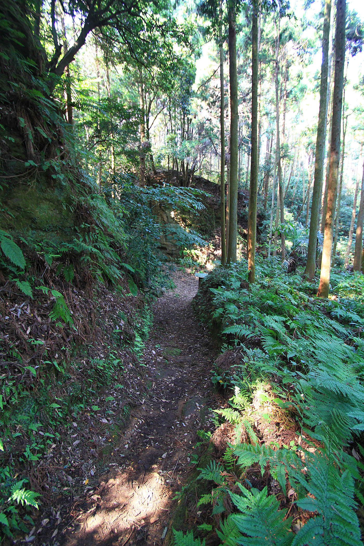
Once up to the summit, I hooked up with one of the trails that I used as part of the Takatori to Sengen-yama (Duckpond) connector.   I was not going to take it all the way out to the duckpond trails today but it took me more a couple of minutes to reorient myself at a couple of the trail junctions.    That section was just a good as I remembered.   This was also my first time on the trail during winter so I was able to see a more things than in the past as most of the foliage was dormant.    There were a couple of spots were I had never noticed that I was riding along a ridgeline that was less than 10 feet wide with extremely steep slopes on both sides with homes 100 plus feet below.   Other times of the year the trail is just in a tunnel of green.

More cool Nippon signs

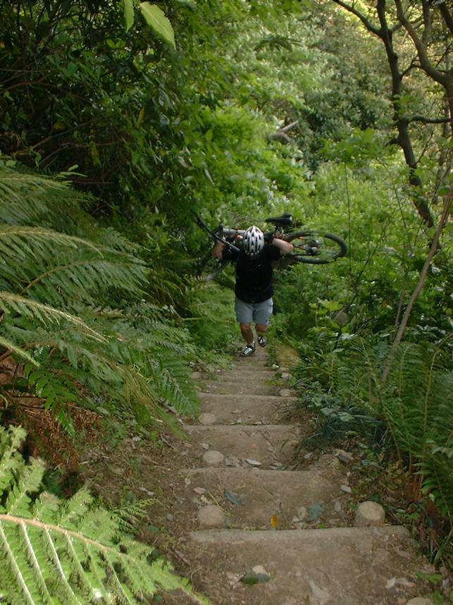
The particularly trail that I chose to peel off on led me to the top of a long series of stairs back down to a street.    Riding these are just part of the mainstream skillset for riding here on the peninsula.   The rental hardtail added some additional fun to this descent.

Da-da-da-da-da-da-da-da-da-da-da-da-da-da…

After knocking out the stairs, I did a bit of street riding to make my way back over to the north side of the Takatoriyama area where I then made my way back up to the summit.

Climbing is what this spot is really known for in the area

From the summit I retraced my way (the trail was really fun in this direction) back the spur I had scoped out earlier in the ride.   This trail worked it is way towards the east along a series of ridgelines between two communities/towns.    There are several exit trails off of these ridgelines and according to my archives there was at least one I had not done before.

It is my understanding that most of this section of trail has a history of being a primary pedestrian route between several of the local communities.  (I suspect trains/buses my have lessened that usage in modern times).   One interesting bit is that there are long sections of this trail which have about an 18″ wide section of concrete walkway poured down the middle of it.   Pretty weird to have a “singletrack sidewalk” through the middle of the woods.    The trail/sidewalk in the woods eventually took me off the ridgeline and in an area of the peninsula I had not been before.     It was a bit of an adventure to find my route back to familiar streets which included traversing more topology than planned but it was all good stuff.

My final week of work in Japan end up being more work than I thought it was going to be so I did not get back out onto trails again.   Well one thing is for certain, my fondness for riding a bike in Japan has not diminished after this visit.

Zushi Double Shot!

After a week full of nasty rainy weather the sun was out! I headed to a trail system in Zushi colloquially known as “Duck Pond”. I have been there numerous time before but it has been about eight years since my last time here. I have a GPS track on how to get there, but I intentionally did not have my GPS turned nor did I look at a map to refresh my memory. Instead I opted to use the Swartz on this adventure. I enjoyed aspect of the retracing my steps. On this day I knew I had a right to make somewhere after getting on the backside of the Zushi train station. In this case a barbershop pole jogged my memory and it was smooth sailing from there to the trailhead. I find spinning through the small streets of Japan and route finding to be just as fun as the trails sometimes.

Using the Swartz

The cheery blossoms were going off of the trees at trailhead entrance.

Chery Blossoms thinking about spring

Ye Ole Duck Pond

Duck Pond

To get up on the ridgeline where the trails are require some work from Duck Pond. Nothing like some hike-a-bike get you going.

So much steeper than it looks!

Once up on the top the rolling sometimes contouring singletrack started.

Got Roots?

I was thoroughly enjoying myself getting reconnected with this “old friend” of a trail system. You get to see more stuff during the winter months when the foliage is sparser. In addition to seeing some of the exposure which is otherwise hidden you have more opportunities for distant scenery. On this particular day Mt Fuji could be seen.

Mt Fuji making an appearance along the trail

I did take one trail that started dropping elevation off in a hurry. By the time I realized this was really not the way I wanted to go down, I really did not want to go back up. So I took the trail down to the bottom and would get back up another way. I got back up onto the ridgelines by climbing the Asaina-kirodoshi. It is one of the seven greater notches through the mountains leading to and from Kamakura. Kamakura is surrounded on three sides by steep mountain and the notches served as defensive passages and passes through the mountains back in “the day”. “The day” in this particular case one was 1241. I climbed up from the west and I was quite satisfied with my performance through the technical sections of this climb. The picture below is from the saddle.

From here I did some more exploring/reconnecting with the trails up on the ridge that included passing by the back side of the Kumano Shrine.

Backside of the Kumano Shrine

When done on the trails up top I would come back by this shrine again and connect up with another trail that would drop me down into Asahina. The bottom of this trail rolls right through a community farm space which always makes me feel like I’m sneaking through someone’s backyard.

The trail going through a community farm

From here this was have been a good time just cruise back along the streets. There was however plenty of daylight left so I decided to go through one of my other trail systems I am fond of Takatoriyama.

The road route to get over there was not particularly straight forward. I decided to give Google Maps a shot at getting me over there. After selecting the walking route I was on my way. Well the walking route was the most direct route but it did include a bountiful amount of stairs. Once the route become clearer to me, I turned off the guiding voice of pain in my pocket and worked my way along the streets.

Off the beaten path treasures at Takatoriyama

As I climbed up the street on the north side of the mountain, I pulled off on a side trail I recognized to check out some of the shaded relief carved to the walks of this old stone quarry.

Off the beaten path treasures at Takatoriyama

My legs where getting pretty well cooked at his point so I opted to settle for a long distance view of the budda vice committing to the work to get over to it. Below is a closeup from my 2009 visit here.

The Takatoriyama Budda as seen on a 2009 ride through here.

Once at the quarry/peak it took me a minute or two to get my bearings straight for the connector I wanted. Twenty seconds down the trail I knew I was on the right trail as I recognized the spot where I had one hell of an endo in 2004 which left me with a cracked sternum. The Ghost of Biker Injuries Past has a long memory.

A section of trail on Takatoriyama

I had worked my way south along what seemed like half a dozen plus trail junctions. I ended up resorting to loading up my old GPS files as my legs were doing some serious wanking at this point and I was not up for more bonus mileage. Turns out I was less the 100 yards for popping out where I was expecting too.

It’s not a train!

The final bit was descending some steep little residential streets and then going through one of the largest pedestrian/cyclist tunnels I have ever been through. It is wider than the street I was on. After that it was about 6 or 7 miles of street riding back to the hotel.

What a great day to be out and about!

Ogusuyama Wanderings

For my second outing on the trails near Yokosuka,  I paid a return visit to Ogusuyama.  When I lived here in Japan for most of 2004 this was my twice a week lunch time loop.   On this trip I was loosely going to follow that same route.   That was the plan anyway.   Things went a little off kilter right from the beginning.    I am staying at a different hotel than I have in the past.   Instead of riding from my hotel back to the my well known starting reference point I decided to just cut through some side streets and connect up to my known route “mid-stream”.    So off I went cutting this way and that, cross checking with my phone.  (More on the phone in a future post).   After working through some unfamiliar side streets, I came out to a junction where the memory banks fired off and I knew where I was at and which way to go.    I stopped looking at my phone at this point.     As I am rolling along, visual cue, visual cue, bang, bang, bang, I have been here before kept clicking in my head.   I was rolling.    A fair ways down the road I noticed that the route had not turned uphill yet.   I should have been climbing by now.   I checked on my phone and realized I had been going off a tangent for over three miles.   Looking at my phone I realized there was no corner to cut to get back on track.  Three miles and change back the way I had came was the quickest way.  WTF happened came to mind.  How did my eyes fail me?    A bit of further reflection and it dawned on me.    I was following the visual cues from memory towards the wrong trail system.    I had clued in on the streets I taken in the past to head over towards the Takeyama Trail System.     That is what I get for being too cocky about my recollection of the streets and roads of this area.

So after backtracking and getting onto the route for the trail I wanted to ride on things started clicking properly.   There was climbing to be done and the good news was I was warmed up.

Visual Cues
Bamboo along the side of the street

One thing about riding on the residential street here in Japan as you start getting up in the hills they often will be single lane.   I kind of did a snicker while shaking my head at the thought that many of our San Diego County multiuse “Trails” are nearly twice as wide as these residential streets in Japan.

Ogusuyama looking to the west towards Segami Bay

Once onto the dirt I made my way over to the summit that included some hike-a-bike up some stairs.  Once on top I was surprised to be treated to some signs of spring.   This was quite a contrast to the beginning of the week where it had snowed.

Cherry Blossums
Signs of Spring

After getting my fill of the sights on the summit I backtracked a bit and got on what was supposed to be my main trail to shed off some elevation in nice single track fashion.

I was quite bummed to see the trail I was looking to take was well blocked off.    None of the other options I knew were appealing as they would put me on the other side of the peninsula, involve hundreds of steep steps carrying a bike or go back the way I came.

Ain’t No Engrish here!

There was a map nearby that clearly laid out in Japanese what to do with the situation.  It was a real bummer to see how much of the trail was closed.   I was hoping that the reroute would not be some hike a bike down BS.   Just when I was about to roll out a hiker came up and was looking bewildered into her phone.     She clearly asked me for directional help but my Japanese has atrophied down from his highpoint of bad some number of years ago.   After a couple of  rounds of international charades and collective pointing at her phone I figured out where she wanted to go.    The trail down the mountain she needed to take was no shown on her phone.    It was not much of a back track for me so I rode back with her following and got her on the right trail.    I remembered the trail as it is a calf burning hike-a-bike on the way up that is not easily forgotten.

My reroute goes through here

My good deed for the day done, I started off on my reroute.   The trail it took me on started out quite flowing but soon turned quite steep.   Luckily it was not also slick so some technical roots and crotch riding the rear wheel took me down to a street.   The reroute then took me through what looked like somebody’s backyard farm before I was back on a micro-sized residential street.   After a bit on the street I was off onto a single track and then back to gravel road.  Shortly thereafter I popped out at the bottom of the closure and familiar ground.   While I was bummed about the section of trail I could not ride, the forced route finding and new bits of trail I went on was a nice bit of unplanned adventure.

Such a nice bit of trail

The next section of trail was just as nice as I remembered it and it popped me out near the entrance to a couple of shrines and temples.    Checking these out were not on the agenda today (I have toured them before) so I continued along the remainder of my old lunchtime loop route.

Here is the spot on Google Maps.  There are four pins in area for the shrines and temples that include photos as well.

The remainder of the ride was street riding back to my hotel.   There were not further navigational misdeeds on my part.       It was great day to be wandering around on Nippon dirt!

Back in Japan – Yoko Dirt Time

Due to my last work project running long in Sasebo, my time back at home was just a week long before I headed back to Japan for some work in Yokosuka.   I flew back into Japan on a Saturday evening and decided to try and shake off some jet lag with ride on Sunday.

After grabbing a rental bike and setting it up with my pedals and some sizing tweaks I was through on the bike garb and on the road.   Today was not an exploration ride but a return to the Fugato-yama area which is one of my regular stomping grounds when I am in this neck of the woods.

It was a beautiful sunny day with a touch fall briskness in the air.  Despite only having about 6 hours of sleep after being up for 26 hours I felt really good on the street riding out to the trails.   I think this was a combination of being a bit fitter than I have been in the last six months coupled with still be ing a bit on Japan time with only having a week on US time.  Whatever the reason, I was digging having some energy in the tank and some iron in the legs while out in some nice nature.

The trails were in exceptionally good condition.   Obviously it had not rained heavy for maybe a week as some of the sections that are hellishly slippery when moist were fairly managable which was another bonus. 

It was a substantual act of being unselfish that I stopped to take this photo.  This is a long section of awesome flowing gravity feed goodness that just makes you smile.  Most times of the year the steep hillside is somewhat hidden by the vegitation.  With winter on its way the mixed forest flora is thinning out some to reveal more of its often “stealth” exposure.

Yoko-Reflective Sign

I did not have a huge route planned out here on this day as I had plans for the evening.   I had a handful of street miles to ride back to my hotel after popping out of the woods.  So there I was “just riding along” on the sidewalk along highway 16.  I managd to clip a sign like the one above while going about 20mph that jerked my handlebar pretty hard.  I was able to correct enough to keep from going full on body surfing on the concrete but the bike went way off line and Iended checking a concrete wall with my shoulder.    My head also smacked the wall, but my helmet completely earned its keep so the melon was no worse for wear.

For those who have been wondering, my test reveal that roadside Japanese concrete seems to have an average grit fact of somewhere between 30 and 45.   

After a very stingy shower, I hopped back on the bike and rode a did a few more miles of street riding over to friends Ken and Emi house.   We had nice evening of catching up things over tasty Japanese microbrews and a yummy homemade dinner.   It was a mighty fine opening day back in the land of the rising sun!

A Nippon Weekend In Review

So I’m back in Japan for a couple of weeks of work.    This marks the first time I have been here in the late January, early February timeframe.    With the highs in the low 40’s and the night time temps below freezing it is downright cold for this San Diego Weather Weenie!   Wednesday was spent playing planes, trains and automobiles but with the international date line thing after getting some sleep in the hotel I woke up to Friday morning.   Friday was spent setting up for work that was start to start on Monday, give a presentation and make rounds of gripping and grinning.     In the middle of all that I picked up a mountain bike rental that not only would be my primary means of transportation while here in Japan, it was also be my recreational vehicle.    Friday evening was marked by the full blown onset of  Jet Laaaaaag!   

I have found that nothing helps to beat your body clock into a new time zone like some exercise.    After some early morning work preps it was time to set off on the bike.     Cold is cold, but the breeze was just downright biting so there was plenty of layering when donning my MTB apparel.   As in all of it!   I was pretty stoked with the hardtail rental I got.   I was the first person to rent one of the newest members of their rental fleet, a well equipped (for a rental) Jamis Durango 1 hardtail. 

 The plan for Saturday was not to do any exploring, just stick to a series of trails that I know and love in the  Fugatoyama area.   It is a rather large chunk of mountainous open space that is for the most part quite rugged.   It has been the source of many memorable head scratching intersections and brutal hike-a-bikes.

One nice change about riding here in the winter time is that you can see a lot more stuff as some of the trees have shed their leaves.    The picture above would be of mostly a veggie tunnel in the summer.   I had a good time out on the trails but was fairly skimpy on taking pictures. 

The final segement of trail along this route dropped me out into an area called ghost-town for the number of old vine entwined buildings that are rusting back to mother nature.    The little paths and streets quickly takes you back down into civlization where one can obtain tasty hot coffee out of a can.   This is straight up yummy caffiene crack in a can!  A nice warm can of coffee in the middle of a cold ride.    Good Stuff!   After the caffiene recharge there was a series of street riding back to my hotel.    I caught up with old friends over a home made dinner that night.   A mighty nice start to trip.


I did not get an early start on Sunday so as to let mother nature warm things up a bit before I went out.    I had been wondering about a different route into the Fugatoyama area that in theory would cut out a bunch of the street riding.    There is a foot bridge over the Yokosuka-Yokohama Expressway that seems to go from nothing but woods on one side of the expressway to nothing but woods on the other side of the expressway.    There has got to be a trail there.   I had never been able to figure out how to get down off the Fugatoyama ridgelines to this footbridge.   I was going to figure this out from the opposited direction on this outing.  The plan was to start from town and get up to the footbridge and then get up onto the ridgelines, where I should know where I am at at that point (That was the theory).   So after some Google Earthing, some exporting and file conversions I had my GPS uploaded with with some waypoints and tracks to investigate.    While not the most direct route to where I wanted to go the route took me through a pedistration tunnel.  Pretty cool. 

After a bit of here, there and to and fro I ended up at my first objective, an entrance into the Taura Plum Grove.  Just after the spot pictured above I got in some stairway to heaven action. 

The Taura Plum Grove is a park and while for the most part it is a rock sidewalk affair it was pretty cool looking.   Springtime here when the plum trees are blooming must be a really awesome sight.   Things are not flat here and my route was taking me to the upper west end of th park so it was a climbing affair. 

Up near the top of the park the views open up.   Tokyo Bay is in the distance and the large building in the distance on the left-hand side of the pictures is the Landmark Tower in Yokohama.

 At the top of the park is a viewing tower where even better views of the area can be taken in.

I was more interested in what was just beyond the tower.  Finally some dirt and the trail that would take me into the Fugatoyama/Muira Alps area.   The trail became a skinny singletrack as soon as it left the park and before long I was across the footbridge and headed west towards the ridgelines.

I had a stupid grin on my face at this point. 

 Some nice little technical rooty bits to contend with.   Big smile on my face here as well.

 Okay, the smile on the face was about 50 feet back behind me at this point.  The trail turnned sharply up a mega-steep ridge side.   The picture does not do the steepness of this section justice.   The good news was I was gaining elevation quickly even if I was not riding the bike.   I was thinking that if this gets me up on the ridgeline where I think it might I will have lots of mostly downhill goodness to ease the kinks out of my hike-a-bike calves.

 I did recognize the trail when I finally did make it up on the ridge.   It was promptly followed by a big “Oh Shit”!  I was much further to the south than I thought I would be and I was exactly at my most southern point of exploration along this particular ridgeline.    The Oh-Shit was because I knew that I had three technical hella-steep hike-a-bike sections between me and the full-time ridable “money dirt” to the north.    My GPS said I had one hour and 23 minutes before sunset.  Farting around was no longer an option.

There were some exposure bits that are hidden very well by the flora, but wintertime has allowed them to me a bit more revealed.   I had only ridden the section above only during the summer months before and I while I knew there was a bit of drop of here I had not idea just how freaking far one could tumble from here until today. 

I made good time through the hike-a-bike bits and was soon back on the money dirt.   I took the shot above and put away the camera and enjoyed some sweet flowing trails that was nearly all downhill to the north.   I popped out of the woods just before sunset and enjoyed an extremely brisk street ride back to my hotel.    A mighty fine way to get primed for a week of work ahead.

A Zushi – Kamakura stroll about

Okay I have been back from Japan for nearly a month now and I am just starting to get caught up of some of my goings on while in land of the rising sun.    On one of my weekends there I set off to do a ride that I would involve a bit of this and a bit of that as far as riding goes.  I know quite a few trails over here and while I wanted to get in some dirt time I was also interested in taking in some of the sights and sounds of Japan life as well.   So I set off on my ride with a bit of eye for looking for new things along an old route.

I started out in Yokosuka  on the eastern shore of the Muira peninsula (about an hour and change south of   Tokyo) and pedaled the streets over to the city of Zushi.    The route itself is always interesting with lots of  Mom and Pop stores, stairways to temples and narrow streets and sidewalks.   There is this school that I pass by along this route and while I Have seen kids at play on it a few times in the past for the most part it was empty during my passings.    Today was quite different.  There was some kind of the school function that involved both the parents, kids and facility.   There were lots of chants, shouts, cheering and laughing on the playground.   I was already well down the street before I decided I needed to check this out with more than a pedal by so I hit the brakes and went back.

There was a hilarious race being held that had me laugh my arse off.   It looks like four groups of parents and children were split up into four teams. They were in lines at one end of the field and some guy/official was sitting in chair at the other end of the field.  At the man’s feet were two burlap sack filled with something.  One sack was small and the other was large.    Once the whistle went off, the person at the front of each line ran across the field to their corresponding guy in the chair at the far end.  As they approached the guy that had to play the guy in a single hand of “rock paper scissors”.   If the runner won, they got the small sack, if they lost they got the big sack.   Either way you the runners had to take their sack back across the field as fast as they could and hand it off to the next person in the line.   For the subsequent runners, winning the rock-paper-scissors bout meant you got to keep or get the small sack.  The entire race we exceptionally funny to watch.

After getting in my fill of giggles I soon veered off the narrow streets and onto trails on and around Mount Sengen.   Most of the locals refer to this area as “Duck Pond” as the most common route has you starting at a small pond.    It has rained quite a bit over the past week and the trails had a lot more moisture than I had expected.

The soil here is clay based and while it does not cake up on your tires at all , it is some exceptionally tricky stuff to ride on where power and balance but be carefully finessed to keep yourself from becoming an amateur geologist taking unplanned soil samples.

Now sprinkle in some leaves and wet roots over this clay and you have some exceptionally interesting bit of trail to content with.   You can find more information about this kind of stuff on Slickopedia.

One of my favorite little curves along the route, the ferns in this area almost popping.  Like many of the hiking trails in this area they have a long history of use to connect between the numerous temples throughout the peninsula.  This particular trail dates back to around the mid 1300s.   After dropping this trail off of west of Mount Sengen, I did a bit of residential street riding before hitting up another series of trails.   Shortly after this I found myself at several trail junctions enjoying the scenery while I sorted through the scribbled on maps and disjointed GPS files floating around in my brain.   Eventually I channeled “The Schwartz”  and figured out my way (The other ways, are now officially on my to-do list).

The series of trails I was on at this point where leading me to Kamakura on the western side of peninsula on Segami Bay.  These trails were created sometime between 1185 – 1333AD.      It is really kind of cool knowing that you are riding a trail nearly four times as old as my home country.

The drop into Kamakura proper is not a gentle one,   there is some seriously steep and slippery steps to contend with as most of your elevation is cashed out rather quickly.

The final bit of the trail before hitting tiny concrete pathways and alleyways that led down into the streets of Kamakura.

With its numerous temples and cultural shops and restaurants one could spend weeks enjoying Kamakura before they would feel as if they have done more than scratched the surface.     For me it was a quick stroll along the streets.

The “scramble” crosswalk.   All traffic briefly stops and pedestrian pandemonium ensues.    Very cool to watch.

This was what  I was really looking for on this day, some of the tasty street vendor offerings.   This stuff is some form of grilled chicken skin/bits will tasty sauce and shredded veggies.

So what if is bad for me, but yeah there were a bunch of skinny Japanese folks eating this stuff so how bad can it be.    After  mowing this thing down and a bit of Japanese fashion watching I made my way back over to Zushi along the streets.   I had big plans to hit of up the trails of Fugato-yama on my way back but by the time I reach the turnoff street my legs were wanking so I continued along the streets back to Yokosuka.   Turns out I did just a few yards under 27 miles so I did not feel bad about bailing on the last riding area.     Another good day to be on a bike and a great day to be out stroll around in Japan.

A Rising Sun Ride

Work has me in Japan for a few weeks so it was about time to get out and hit the trails.    The fall weather here is pretty nice so I opted for a crack of dawn ride as my Saturday midday was already booked up.  The previous day had been remarkably clear and tomorrow was supposed to be overcast so I was hoping to catch a window to see Mount Fuji at dawn on top of Ogusayama the tallest peak on the Muira Peninsula near Yokosuka.  It was still pre-dawn when I rolled out of the hotel at 5AM but not by much.   The ride along the city streets was really quite and almost surreal.  It was pretty much just me and the cats along with couple of early risers like myself.

The street riding to the trails is mostly uphill the entire way.  Before long I turned off the primary streets to smaller and smaller secondary streets as things became more rural and I started passing little family farms.   I was nearly to the dirt trails when the rising  sun joined me on the ride.

In 2004, I spent the better part of year living over here and I rode the Ogusuyama trail network numerous times so this place is kind of like home away from home dirt.  Fall is just thinking about starting here so the colors are not happening yet but the leaves on some of the trees are starting to get a little sparse so views occur a little more often.  This typically reveals just how steep some of the hillsides are that the trails cut across. 


I made pretty descent time to the top of Ogusuyama, but there were some distant clouds so Fuji was in hiding.   So while the planned far-view scenery was not to be had, the nearby stuff was pretty awesome as a clearing near the top of the mountain was flush with flowers.

After the stopping to smell the flowers break, I opted to continue heading west down the other side of the mountain to the Segami Bay side of the pennisula.  The trail I took has a lot of fun flowing sections but it makes you work for them as thier are some really rooty sections that require all of your bike handling attention.    If the roots alone were not interesting enough the soil in this area is mostly clay and with the rains a few days prior the bare clay sections had traction qualities that are best described as “I Can’t Believe Its Not Butter”.     There were many times along this trail where I’m sure my facial expression would be best described as being that of a “terrified smile”.  

Below is one of the sections that was just blissfully fun.

Eventually the trail came out on a tiny litte street about the size of the golf cart path that feed to a series of other streets each a little wider than the last until I came out onto the main two-lane street down by Segami Bay.  I did a bit of flat-land street riding to connect up with a another street that would turn into a fireroad that would take me back up into the Ogsuyama area.  Before getting back into the climbing gears, I had to grab a bit of morning coffee.   The vending machines over have canned hot coffee which are simply awesome.   I am big-time addict of these coffees and being able to grab a quick fix on a ride is pretty awesome.    Coffee Crack in a can — Good Stuff!

After getting my coffee buzz on I was climbing back up the mountain. The grade was a bit steep in spots and it felt good to get some burn in the legs. Once back up near the top of Ogusuyama I took a different set of trails that would take me to southeast and down into the community of Kinugasa.   As I rolled off the trail I was quitely in the town which was fully awake now with lots cars and people fluttering about getting their day taken care of.   It was a little bit taken back by it at first due to the  juxtaposition of the sleepiness of the streets a few hours ago.  From there is was quite a bit of street riding back to the hotel and before long I too was fluttering about getting the rest of my day taken care.   I think I am going to have to do another rising sun ride before I leave Japan.

A Little Land of the Rising Sun Action

After spending a few days in Seattle finishing up some work, I headed out to Japan to spend a week scoping out a project for next year.   As always I was hoping to squeak in a ride if time permitted.   I rented a mountain bike for the duration of my visit to serve as my primary means of daily transportation and potentially some recreation as well.   The weather was  forecast to be pretty much icky for the week with Wednesday being partly sunny.    Wednesday came around and partly sunny was indeed the case with a full serving  of windy and brisk to boot.   I was able to open my afternoon enough to get in some “Off-Site Strategic Planning”  accomplished on the bike.   While I still have some places to explore in this area on my list from previous visits, I would not have time for that with the shorter days October.   I had a handful of miles to ride on the streets to get to Zushi City where I would pick up the first part of the afternoon’s dirt adventure.   I had nearly forgotten just how culturally interesting in can be riding on the streets over here.   Narrow sidewalks, mom and pop businesses, scooters whizzing by, Japanese School Girl Uniforms, lots of people out walking and peddling, etc…  It is just an intersting scene.  

On one section of road with a bit of a climb in it I came across a new sign that was not there in June of last year.  I can’t read this sign but I know what it means.  And I like it.  The Japanese have a knack for iconing things so that just about anybody can figure things out.  Rider Up!

Once I made it over the Sengen Trails which is commonly referred to by us Engrish folk as Duck Pond since the trail starts at a small pond that typically has ducks in it. What a bunch creative Gaijins we are .  The trail starts with a heiniouly steep hike-a-bike up to a ridge that typcially requires you to shoulder the bike.   With the rain the day before I knew this was going to be a fun section with plenty of slick clay.   It was about this time I thought about the fact I had never taken the trail around this little pond.  So I decided to delay my hike-a-bike fun and go around the pond.  I was fairly stoked to find that at the end the pond was a little boardwalk that was quite fun on the bike.  It was just tight enough to be interesting and combined with the really brisk air and the thought of falling into the shallow mucky end of this pond made this section downright fun.  I had to do it a couple of times in both directions.   This was a pretty cool 5 minute detour and added some newness the ride right out of the gate.   The Hike-A-Bike up to the ridge was every bit of clay treachery I expected, but I was soon rolling along the ridgetops. 

After climbing along the trails I made it up to the top of Sengen Hill (or Peak – can’t remember ) there was some nice views of the mountains in the Hakone National Park in the distance, but it tooks some effort to see as mother nature is reclaiming the clearing in a hurry.  As is often the case, Mt Fuji was hiding behind distant clouds.  From here it was time to head down and I took one of my favorite routes down through the Tennin trail system before popping out on another street.  

After a short bit of road interconnecting I got onto a series of trails that headed westward towards Kamakura.   There are some really good trails that are quite popular with hikers.  Many of the trails are hundreds of years old with some of the more direct routes between the temples being over a thousand years old.   

There are several sections along the route where the trail cuts through the top of the ridge via a slot or notch.  Sometimes the notches are 20-30 feet deep.  I orginally thought that this was a result of the trail being “cut” by some machinery or tools sometime in the past.   The slots in the ridge were actually created from the countless footsteps of people who have walked these trails for hundreds of years.   Feet, time and errosion have cut through the ridge tops.  After riding and climbing along these ridges the exit was like most of the trails in the mountains around here, Hike-A-Bike up and White Knucklers on the way down.   The wet conditions earlier in the week made the descent quite challenging to ride and not much easier to walk.    There was a least a couple of clay samples taken.

Once I dropped off the ridgelines down into Kamakura I worked my way along the streets back to Yokosuka and my hotel.  Later on that evening I met some old friends for dinner to catch up on thngs and to fawn over their new baby girl.   It was good times on pretty much all facets of the day.

Added Takatori to the website

I finally got all my notes, photos and map information together for the Takatori-yama area near Zushi and Yokosuka, Japan.   I added a Google Earth KMZ file to this review that is mashed up with my photos and trail notes  as well as Japanese topo map to help you get to know the area better.  One thing I like about this setup is that you can find all sorts of other information on the area in addition to photos from other people.  If you find yourself in the area you should definitely check this place out.  For all my peeps on the Far East Side that call this place home, keep the trails ridden and shot me some more information on the trail spurs I did not get to.

The Takatori-yama Page

Fugato-yama exploration

Well I’m back on the right side of the International Date Line and I must say I had a really cool time in Japan but I’m glad to be back at home where I have more “normal” things to fill up my day like leaky facets, broken sprinklers, kid’s hockey games and other family goodness.

The last two weeks in Japan were pretty busy so not much time to play online, but I did get in some riding.  Specifically I went out to the largest chunk of forest on the pennisula.  Most of my friends refer to this area as Fugatoyama, but it is actually a sizable chunk of the Kanagawa Wildlife Protection Area that has several names.  Topology-wise there are a series of ridges lines that form a reverse C shaped bowl with a river that forms and flows from east to west  of out the outlet of “the bowl” and onward to Segami Bay.  Most of the riding occurs and the northern leg of the “C” and down the northeastern flanks of the ridgelines down to the Tokyo Bay side of the pennisula.  

In 2004, I had done quite a bit of exploring on the southern leg of the reverse C. There are nice sections of trail in that area interspresed with hike-a-bike and aggressive sections.   If you have ever ridden Bell Ridge or Los Pinos in Orange County it is sorta like that but forested and the trail is often criss-crossed with roots.  I had snooped around for connections between the North and South legs but had mostly found brutal steep hikes that were “Advanced/Expert Hike-A-Bikes”. 


I really wanted to find a connector that only included some “Upper Intermediate Hike-A-Bikeage”  After a good bit of research I had some proposed routes that inlcluded going into “The Bowl”.   There is an awesome chunk of trail going into the bowl.  It is wonderful sweeping flowing singletrack that gracefully looses its elevation into the bowl.  I was hoping to find such another trail leading out of the bowl to the south.   Hope…..Hope on it’s own is for idiots who are too stupid to come up with a plan.  The plan was to be mentally prepared for a brutal hike-a-bike up to the south or bailout on a proposed trail along the river to the west.

“The Bowl” is an amazing wooded area that rivals some of the best forested scenery I have ever been in. I found myself not making much headway and I was enjoying every minute of it.  

I learned a really interesting bit of information from some of the locals about the snakes of Japan.  All of the venonmous snakes have slited eyes while all of the non-venonmous ones have round eyes.   The drawback to practically applying the information is that you have to get close enough to them to figure it out.

After exploring most of the options in the west end of the bowl I was soon started picking trails that would take me towards the southern ridges.  The bowl is not as much of a bowl as I had expected as there were some smaller ridges inside of the bowl that proved to be beaters.   This was by far not the first I had failed to fully appreciate the thin topo lines spaced closely together.   My payment to the mountain gods would come in the form of burning calves and triceps as I carried, lunged, and pushed my bike up the trails less traveled.

Once I had gotten up onto these intermediate ridges, I was presented with some trail options that left me scratching my head.  It was one of those things were I was pretty sure were the splits would take me but knowing and confirming are two different things.  I took a couple of these options as out and back to confirm were they were coing before continuing along my intended route.  

The next series of trail options shed off yet some more elevation and took me further down into the bowl.  When I reached a point where there was supposed to be a four-way intersection, I only found a T-intersection with my intended direction being the missing leg.    From pouring over my Japanese maps I figured out that I would have to take a long uphill climb that would most likely be hike-a-bike way to the west to catch the southern leg of the “C”.  I already knew the southern leg would also have a bit of hike-a-bike between the riding sections.   I was feeling fatigue creeping in but more importantly I was mentally growing tired of the hike-a-bike exploring.   I opted to take the trail option that followed the stream/creek downstream.

Boy was I glad I went that way.  After a good bit of technical riding, the trail started mellowing out and the riding got real flowing and just awesome.  I now started encountering some hikers here and there.  The further west and downstream I went the more mellow things got.  This was one hell of a great “bailout”. Eventually the “trail” ended at and old road that has been turned back over to mother nature when the wildlife protection area was established.   Mother Nature is doing a mighty fine job with this road.

Over the next few miles the trail/road turned to a dirt road, then a paved road and before long I was back in rural civilization.   I ended up taking a series of streets and trails back to the apartment.  While cruising back I got to thinking that if this was back in the states, it would surely be designated wilderness area or some kind of sensitive area that would be off-limits to bike.  Hats off to the Japan and thier outdoor culture.  Trails are trails over there.  You can ride your bike anywhere you dare too including national parks and thier wilderness equivalent.  From what I understand there are only a few trails in the entire country that are off-limits to bikes. One of them is Mount Fuji and that is closed only during the busy hiking season.  After dinner that night I broke down and packed up the bike and got all packed up to finish that last bits of work and fly home the following evening.