All this remastering videos has really got me jonesing to get back on some trails. This video was from April of 2004 inZushi, Japan. The area was also known as “Duck Pond” as one of the entrances into the area required a righteous hike-a-bike up a trail behind a duck pond. This area was also part of bigger adventures into the Tennin, Takatori, Yokohama Woods and Kamakura trail systems. I had some really good times out in this area.
Some of these trails document back 800+ years
At 1:40 you will see us pass by the back of the Kumano Shrine which was first built in the eighth year of the Japanese Genroku Era which equates to 1696AD. As best as I can research it was last refurbished in 1978.
At 2:52 and 4:45 until the end. We are on the Asaina-kirodoshi. It is one of the seven greater notches through the mountains leading to and from Kamakura. Kamakura is surrounded on three sides by steep mountain and the notches served as defensive passages and passes through the mountains back in “the day”. “The day” in this particular case one was 1241AD.
I have been in this area of Japan quite a few times. Check out some of my other blog posts from those trips. If you would like to see some some old school photos shot with my then fancy 1.2MP camera check out this old page.
Another remastered video from the Pre-GoPro Era of camcorders and burly neck muscles. While working in Japan in 2004, I had the opportunity to circumnavigate Lake Ashi (Ashinoko) using the lakeside trail and the Skyline trail. Lake Ashi is located in the Hakone area of the Kanagawa Prefecture of Honshu Japan. It is very scenic and Mount Fuji can often been seen from spots along the shore shore and the ridgelines around the lake. This was a big day out on the trails and a whole lot of fun. Here is my account of the day.
My final outing on the mountain bike for this trip to Japan was to head back out to the Takatori area east of Zushi. I passed through here on my lasting outing but it was mostly a transit through it. This time I wanted to futz around a bit.
Coming in from the south
I did some street riding from Yokosuka to make may way over to the entrance of the trail system. Like most of the trails in the area, you have to do so grunting immediately after the leaving the streets.
Trail Goodness
I entered the trail system were I had exited on the last outing and I was planning on retracing my way back up to top of Takatoriyama. I was however going to investigate all of the various spurs that split off of the main trail I was on.
There were a few spurs of particular interest to me as I remembered them as being really cool during my last time on them more than a few moons ago.
I just love these kind of locals helping folks signs.
So much steeper and slick than it looks
I was armed with my GPS loaded up with my personal archive of adventures in this area. The goal was to jog my memory and avoid a few of the spurs that will quickly dump you off the mountain resulting in pain and/or hike-a-bike to get back up to the prime riding stuff.
Trails old enough to have worn notches through the peaks of the hills.
On my way up to the summit, I did find the junctions that I wanted to hit on the return half of the route. I even came across about five other mountain bikers out on trail. One interesting thing I noted about this group was that while most of them while had rather high-end new bikes (Within 2-3 years), none of them were running single chain rings up front. Actually most them were running triples up front. My theory is that most them ride their bikes to the trailhead which according to where you live on the peninsula you can easily end up being 7-10+ miles on the streets/roads. While my rental rig is pretty much old and has seen better days I find the big rig to be a really welcome feature on it.
Once up to the summit, I hooked up with one of the trails that I used as part of the Takatori to Sengen-yama (Duckpond) connector. I was not going to take it all the way out to the duckpond trails today but it took me more a couple of minutes to reorient myself at a couple of the trail junctions. That section was just a good as I remembered. This was also my first time on the trail during winter so I was able to see a more things than in the past as most of the foliage was dormant. There were a couple of spots were I had never noticed that I was riding along a ridgeline that was less than 10 feet wide with extremely steep slopes on both sides with homes 100 plus feet below. Other times of the year the trail is just in a tunnel of green.
More cool Nippon signs
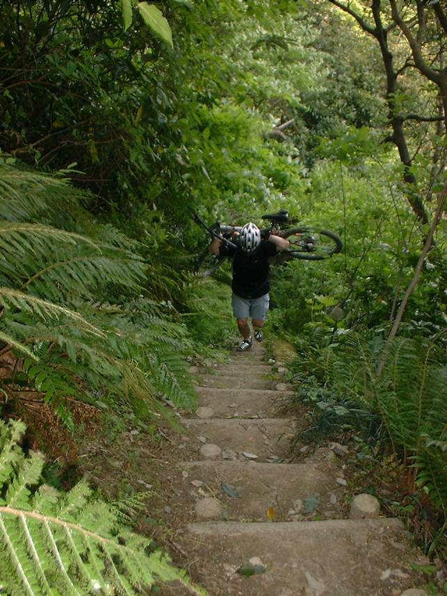
The particularly trail that I chose to peel off on led me to the top of a long series of stairs back down to a street. Riding these are just part of the mainstream skillset for riding here on the peninsula. The rental hardtail added some additional fun to this descent.
Da-da-da-da-da-da-da-da-da-da-da-da-da-da…
After knocking out the stairs, I did a bit of street riding to make my way back over to the north side of the Takatoriyama area where I then made my way back up to the summit.
Climbing is what this spot is really known for in the area
From the summit I retraced my way (the trail was really fun in this direction) back the spur I had scoped out earlier in the ride. This trail worked it is way towards the east along a series of ridgelines between two communities/towns. There are several exit trails off of these ridgelines and according to my archives there was at least one I had not done before.
It is my understanding that most of this section of trail has a history of being a primary pedestrian route between several of the local communities. (I suspect trains/buses my have lessened that usage in modern times). One interesting bit is that there are long sections of this trail which have about an 18″ wide section of concrete walkway poured down the middle of it. Pretty weird to have a “singletrack sidewalk” through the middle of the woods. The trail/sidewalk in the woods eventually took me off the ridgeline and in an area of the peninsula I had not been before. It was a bit of an adventure to find my route back to familiar streets which included traversing more topology than planned but it was all good stuff.
My final week of work in Japan end up being more work than I thought it was going to be so I did not get back out onto trails again. Well one thing is for certain, my fondness for riding a bike in Japan has not diminished after this visit.
After a week full of nasty rainy weather the sun was out! I headed to a trail system in Zushi colloquially known as “Duck Pond”. I have been there numerous time before but it has been about eight years since my last time here. I have a GPS track on how to get there, but I intentionally did not have my GPS turned nor did I look at a map to refresh my memory. Instead I opted to use the Swartz on this adventure. I enjoyed aspect of the retracing my steps. On this day I knew I had a right to make somewhere after getting on the backside of the Zushi train station. In this case a barbershop pole jogged my memory and it was smooth sailing from there to the trailhead. I find spinning through the small streets of Japan and route finding to be just as fun as the trails sometimes.
Using the Swartz
The cheery blossoms were going off of the trees at trailhead entrance.
Chery Blossoms thinking about spring
Ye Ole Duck Pond
Duck Pond
To get up on the ridgeline where the trails are require some work from Duck Pond. Nothing like some hike-a-bike get you going.
So much steeper than it looks!
Once up on the top the rolling sometimes contouring singletrack started.
Got Roots?
I was thoroughly enjoying myself getting reconnected with this “old friend” of a trail system. You get to see more stuff during the winter months when the foliage is sparser. In addition to seeing some of the exposure which is otherwise hidden you have more opportunities for distant scenery. On this particular day Mt Fuji could be seen.
Mt Fuji making an appearance along the trail
I did take one trail that started dropping elevation off in a hurry. By the time I realized this was really not the way I wanted to go down, I really did not want to go back up. So I took the trail down to the bottom and would get back up another way. I got back up onto the ridgelines by climbing the Asaina-kirodoshi. It is one of the seven greater notches through the mountains leading to and from Kamakura. Kamakura is surrounded on three sides by steep mountain and the notches served as defensive passages and passes through the mountains back in “the day”. “The day” in this particular case one was 1241. I climbed up from the west and I was quite satisfied with my performance through the technical sections of this climb. The picture below is from the saddle.
From here I did some more exploring/reconnecting with the trails up on the ridge that included passing by the back side of the Kumano Shrine.
Backside of the Kumano Shrine
When done on the trails up top I would come back by this shrine again and connect up with another trail that would drop me down into Asahina. The bottom of this trail rolls right through a community farm space which always makes me feel like I’m sneaking through someone’s backyard.
The trail going through a community farm
From here this was have been a good time just cruise back along the streets. There was however plenty of daylight left so I decided to go through one of my other trail systems I am fond of Takatoriyama.
The road route to get over there was not particularly straight forward. I decided to give Google Maps a shot at getting me over there. After selecting the walking route I was on my way. Well the walking route was the most direct route but it did include a bountiful amount of stairs. Once the route become clearer to me, I turned off the guiding voice of pain in my pocket and worked my way along the streets.
Off the beaten path treasures at Takatoriyama
As I climbed up the street on the north side of the mountain, I pulled off on a side trail I recognized to check out some of the shaded relief carved to the walks of this old stone quarry.
Off the beaten path treasures at Takatoriyama
My legs where getting pretty well cooked at his point so I opted to settle for a long distance view of the budda vice committing to the work to get over to it. Below is a closeup from my 2009 visit here.
The Takatoriyama Budda as seen on a 2009 ride through here.
Once at the quarry/peak it took me a minute or two to get my bearings straight for the connector I wanted. Twenty seconds down the trail I knew I was on the right trail as I recognized the spot where I had one hell of an endo in 2004 which left me with a cracked sternum. The Ghost of Biker Injuries Past has a long memory.
A section of trail on Takatoriyama
I had worked my way south along what seemed like half a dozen plus trail junctions. I ended up resorting to loading up my old GPS files as my legs were doing some serious wanking at this point and I was not up for more bonus mileage. Turns out I was less the 100 yards for popping out where I was expecting too.
It’s not a train!
The final bit was descending some steep little residential streets and then going through one of the largest pedestrian/cyclist tunnels I have ever been through. It is wider than the street I was on. After that it was about 6 or 7 miles of street riding back to the hotel.
For my second outing on the trails near Yokosuka, I paid a return visit to Ogusuyama. When I lived here in Japan for most of 2004 this was my twice a week lunch time loop. On this trip I was loosely going to follow that same route. That was the plan anyway. Things went a little off kilter right from the beginning. I am staying at a different hotel than I have in the past. Instead of riding from my hotel back to the my well known starting reference point I decided to just cut through some side streets and connect up to my known route “mid-stream”. So off I went cutting this way and that, cross checking with my phone. (More on the phone in a future post). After working through some unfamiliar side streets, I came out to a junction where the memory banks fired off and I knew where I was at and which way to go. I stopped looking at my phone at this point. As I am rolling along, visual cue, visual cue, bang, bang, bang, I have been here before kept clicking in my head. I was rolling. A fair ways down the road I noticed that the route had not turned uphill yet. I should have been climbing by now. I checked on my phone and realized I had been going off a tangent for over three miles. Looking at my phone I realized there was no corner to cut to get back on track. Three miles and change back the way I had came was the quickest way. WTF happened came to mind. How did my eyes fail me? A bit of further reflection and it dawned on me. I was following the visual cues from memory towards the wrong trail system. I had clued in on the streets I taken in the past to head over towards the Takeyama Trail System. That is what I get for being too cocky about my recollection of the streets and roads of this area.
So after backtracking and getting onto the route for the trail I wanted to ride on things started clicking properly. There was climbing to be done and the good news was I was warmed up.
Visual Cues
Bamboo along the side of the street
One thing about riding on the residential street here in Japan as you start getting up in the hills they often will be single lane. I kind of did a snicker while shaking my head at the thought that many of our San Diego County multiuse “Trails” are nearly twice as wide as these residential streets in Japan.
Ogusuyama looking to the west towards Segami Bay
Once onto the dirt I made my way over to the summit that included some hike-a-bike up some stairs. Once on top I was surprised to be treated to some signs of spring. This was quite a contrast to the beginning of the week where it had snowed.
Cherry Blossums
Signs of Spring
After getting my fill of the sights on the summit I backtracked a bit and got on what was supposed to be my main trail to shed off some elevation in nice single track fashion.
I was quite bummed to see the trail I was looking to take was well blocked off. None of the other options I knew were appealing as they would put me on the other side of the peninsula, involve hundreds of steep steps carrying a bike or go back the way I came.
Ain’t No Engrish here!
There was a map nearby that clearly laid out in Japanese what to do with the situation. It was a real bummer to see how much of the trail was closed. I was hoping that the reroute would not be some hike a bike down BS. Just when I was about to roll out a hiker came up and was looking bewildered into her phone. She clearly asked me for directional help but my Japanese has atrophied down from his highpoint of bad some number of years ago. After a couple of rounds of international charades and collective pointing at her phone I figured out where she wanted to go. The trail down the mountain she needed to take was no shown on her phone. It was not much of a back track for me so I rode back with her following and got her on the right trail. I remembered the trail as it is a calf burning hike-a-bike on the way up that is not easily forgotten.
My reroute goes through here
My good deed for the day done, I started off on my reroute. The trail it took me on started out quite flowing but soon turned quite steep. Luckily it was not also slick so some technical roots and crotch riding the rear wheel took me down to a street. The reroute then took me through what looked like somebody’s backyard farm before I was back on a micro-sized residential street. After a bit on the street I was off onto a single track and then back to gravel road. Shortly thereafter I popped out at the bottom of the closure and familiar ground. While I was bummed about the section of trail I could not ride, the forced route finding and new bits of trail I went on was a nice bit of unplanned adventure.
Such a nice bit of trail
The next section of trail was just as nice as I remembered it and it popped me out near the entrance to a couple of shrines and temples. Checking these out were not on the agenda today (I have toured them before) so I continued along the remainder of my old lunchtime loop route.
The remainder of the ride was street riding back to my hotel. There were not further navigational misdeeds on my part. It was great day to be wandering around on Nippon dirt!
It has been quite a few moons since I was last in Japan, and even more since being in Yokosuka. Work has brought me back for a few weeks and I am pretty stoked about. In addition to catching up with a couple old friends and reacquainting myself with the culture I was excited about revisiting some the trails I have fond memories of.
The rent-a-wreak
All of the mountain bikes at my local rental place were out when I first arrived. I really did not have much to ride anyway as there was plenty to do with getting the work project rolling. The second weekend a couple came in and grabbed one.
A mighty fine looking tree
The Fugatoyama trail system I hit up is near Zushi and the route would take me up to Fugatoyama. I had uploaded some of my old track into my GPS. Well so I thought. Turns out I gooned something up and while I had plenty of tracks for the other trails in the area, I did not have the trails I planned on riding.
I love this section
I have ridden the trails numerous times so while not having my “safety blanket” of old bread crumbs I felt confident about being able to find my way around.
Shrine/marker along the trail.
I went to the trails system near the Arden Hills are of Zushi and was soon it old stomping grounds. I had no issues with the figuring and the six trails junctions need to get my way up to the peak of Fugatoyama.
The trail has been around long enough cut a notch through the ridgeline.
After getting to the peak I retraced my steps back to the main junction that was going to take me down to the east side of the peninsula. There are a handful of opinions to get down from where I was at. The downhill was pretty awesome just as I remembered. I got to one trail junction I had real tough time figuring out which way to go. Either way would work but one of them was better than the other and extended your time on the dirt.
I pondered at the junction for quite sometime before picking and I picked…WRONG! The route I took dropped me out of the woods way too quickly. You also shed off so much elevation that I was not about to hike a bike back up to the junction. I guess I’m just going to have to go back!
After some snack Nippon style it was time to cruise back to Yokosuka and my hotel.
I have been back from Sasebo for a couple of weeks now. The last few weeks that I was in Japan was pretty hectic. I did have time to ride but little time to do much posting. Here are some pictures.
From the north slope of Mt Yumihari. I come to loath the rental wreak that I had. Cantilever rim brakes! I now that the hand shake strength of a pair vise grips.
Views found in a break in the foliage.
There was plenty of rain which kept most the trails soggy for way too much of the time I was there. I often did the road climb up to the top of the Mt Yumihari after work. It was almost always a chasing the sun kind of ride. While I typically beat the sun, the rain got me on more than a few occasions.
Views from a park at near the top of Mt Eboshi east of town.
Sasebo as seen from Mt Eboshi
More of Mt Eboshi
More views from the chasing the sun series
I lost the race against the sun on this ride
Intentionally enjoyed losing the race on this evening.
Over the last month that I have been working over here there has been about four individual days that it has not rained for some portion of the day. The soil composition in this area is typically clay based which holds up to the rain well but becomes treacherously slick. The cantilever rim brakes coupled with the 1.75 tires on my rent-a-wreck hard-tail makes riding of this stuff with an moisture on them at all downright sporty.
It rained early Saturday and had been sunny ever since so I decided to test the waters on one of the prominent mountains in the area, Akasaki. The trail has seen some maintenance earlier in the year so the tread was in good condition and the trail was well brushed. I could tell during the climb that traction could be a problem on the descent as plenty of finesse was required on the climb to keep from breaking the rear wheel loose. The views from top were exceptional.
The descent of this trail was however still pretty slick and made for a squirrely descent, particularly in the turns. Notice in the photo above there is some four fingered braking going on. If I would have known my work project was going to be extended by nearly a month, I would have brought my bike over. On the plus side this rental is completely unforgiving so it forces you to handle the bike precisely.
After way too much fun on the “easy” descent, I passed on this trail under the guise of discretion is the better part of valor. I opted to spend the rest of the ride scoping out trailheads and crossings off the back roads of the area for future exploration when the trails are drier.
This sign unfortunately does not say “Hiro-San’s Texas Style BBQ 100 meters ahead”. There are lots of wild boar in this area and I believe the signs either says beware of boars or indicates a typical boar crossing. Ummmm Bacon!
Shirahama Beach was the apex point of this ride. A snack and a little bit of chilling was in order before it was time to start a good bit of climbing on the return leg.
I have come across about half a dozen of these land crabs here in Japan. I was a good half a mile from the ocean and at least 100 feet plus in elevation. These are the basically the same kinds of crabs you see around the rocks in most stateside beaches but these guys have adapted to thrive away from the shorelines here. Mr. Crabs here was pissed.
A view of Kujyukushima from Tenkaiho Park. I have ridden on all of these peaks at one time or another with the exception of the volcano looking peak to the left, Mt Atago. It is still on the list.
This is literally the lawn mowing crew at this park. The grounds keepers stake out the goats and once they eat down their circle they move the stakes. Pretty cool.
Got Grass Will Mow! (Will through in fertilizing your lawn for free)
By the time I made my way “home” I had covered 22 miles and 3,000 feet of climbing. A yummy Nippon microbrew was definitely earned.
Earlier this week, work has taken me back to Sasebo in the southern part of Japan. I’ll be here for about a month and change. I had debated about shipping/bringing one of my own bikes over here for the duration but between the cost and hassle, I decided to take my chances with getting a rental. I’m thinking I maybe should have went with shipping one of my own bikes over as the pickings were slim at the rental place.
The steed for this trip is a total Throw “Way The Hell” Back rig complete with canti-brakes. Brakes is a bit of an optimistic term in this case, slowers is more appropriate. On the plus side, I’ll soon have hands that can grip like a bear trap and I should not be accused of skidding up the trails around here.
The weather guessers were calling for a typhoon to come through the area the following day so getting a ride in before that was a priority. The outdoor adventure center were I rented the bike is more centered on scuba and deep sea fishing than biking so I had to spend quite a bit of time get the bike setup and tuned before heading off for the late afternoon ride. I’m fairly certain that the clipless pedal I put on the bike doubles its value.
When I started out from my hotel room, a nearby thermometer read 90 degrees with the humidity being around 85%. I was sweating and I was barely moving. The climb up Mount Yumihari is on narrow paved roads. The plan was to take the pavement up and a couple of different trails down and then back into town.
The climb is fairly steep and it was good workout. I have done this climb numerous times so I knew what to expect which helped with the climb but I was still getting worked. Once I got to the top I realized that all the pre-ride tinkering had eaten up my daylight margin. I was pretty certain that taking the trails back down would end up being a night ride. A night ride I was not really prepared for. So I went with plan B and enjoyed the views from the top for a leisurely bit before taking the roads back down the mountain. This should help with the jet lag. This is not my first time MTBing in Sasebo so you can find other Sasebo related blog posts here.
Work this past week has brought me back to Japan on a short trip. I did bring along on my bike essentials and on Sunday I was able to take the rental bike out through some old stomping grounds on the Muira Peninsula. It was a cloudy overcast day and while the sun seemed to threaten to make an appearance it never did. The good news was it was not raining.
This started out with a bit of street riding from Yokosuka over to the town of Zushi. I had forgotten to bring my GPS and maps of the area on this trip so the plan was going to be to stick to know routes. When I first got into Zushi was when I had to make my first decision about where to ride. I could either roll over to the “Duck Pond” area ride that stuff and then link up with the Tennin trail system and drop down into Kamakura or I could turn south and hit the Fugato-yama area.
I opted for the latter and after a bit of street climbing and some steep cement steps I was into the woods. The rain from previous days made for some treacherous bike handling as the clay bases soil in the area gets a traction rating of “butter” when wet. Slick sections of clay and wet angled roots all added to the overall excitement of being back on the trails that I have come to enjoy so much. The loop I had planned in the Fugatoyama area included an out-and-back segment up to the peak. On my way back from the peak I stopped at the junction of a trail I had never taken. It drops you way down into a large basin area to the south. Several years ago I had explored down in that basin coming in from the other end. I was quite certain I had been at the other end of this trail down in the bottom of the basin. Taking this trail would not only be a bit of exploration but would also mean committing to the follow the basin trail system down to the west and out on the opposite side of the peninsula from where my hotel was at. I took the path I had never traveled.
The trail was somewhat I expected in that it was steep and followed along a watershed. The previous rain made part of the trail more stream than trail in spots and it was always fairly narrow. I was digging being on some new dirt while hearing the little voice in my head fretting a little that I might be wrong about where this trail is going.
Turns out I was right about the trail once down into the basin, I turned onto a trail that flowed a stream down to the west. The trail was extremely small and rugged with lots of water crossings at this end. The further west you go the more established and less rugged the trail becomes as this trail seems see more usage by hikers at that end.
After following the trails out to a trailhead I followed a series of streets out to the western shore of the peninsula. From there I turned south and followed the roads and streets south through Hyama. The route turned out to be a little longer than I remembered. I was happy to recognize the turn off for the dirt road up Ogusuyama, the highest peak on the peninsula.
I was due for a pick me up so a snack from a local store and one of favorite treats was in order. Canned coffee served hot from vending machines that are all over the place here.
After the caffeine hit I started the grunting up to the peak. I made my way up to the an observatory at the top. From there I took a trail my friends here have simply referred to as “Trail 2” that will take you into the Kinugasa area.
This may be the first time I have stopped to take a picture of this section. Its mighty zippy through here.
Another fine section of trail. Not too far beyond this point I was back on streets and roads and headed back to my Yokosuka hotel. My legs were fairly cooked and mud splattered grin from ear to ear.


