
Well it has been many moons since I did a MTB vid. Lots of reasons why but mostly because I was not particularly motivated to do a video. I have shot lots of video but had a tough time wanting to futz with it at a keyboard. Well after looking at my footage from the North Rim, I felt like putting a video together. So here you go. I’m hosting this on YouTube at the moment and I’m still working out the kinks on getting the video encoding to look its best through them. You can select up to 1080 HD if your connection and device will handle it.
Category: Trails
Trails in General
North Rim of the Grand Canyon
few days ago I got back from a vacation that included a few days in the Las Vegas that included seeing Aerosmith in concert. Wow, can those guys still kick some ass on stage! After the Vegas portion of vacation we continued northward and eastward to the North Rim of the Grand Canyon. This was my third time out here and Nichol’s first. I first came out here on an Arizona in Summer roadtrip in 2006 and then again on a Flagstaff & North Rim trip in 2010. You don’t come out here for technical riding, you come out here for the incredible scenery and the experience of riding on the only singletrack currently open to mountain bikes along the rim of the Grand Canyon. The Rainbow Rim trail is in the Kaibab National Forest and is miles and miles away from pavement, cell phone coverage and any of the tourist trappings of the Grand Canyon National Park despite the border of the national park being just a few feet below the rim of the canyon in this area. The place requires a commitment to visit but it is well worth it.

We made our way out to the Kaibab Plateau on a Monday and made our way out to the middle of five points that stick out into the canyon, Locust Point. We had the entire point to ourselves.

The view into the Tapeats Amphitheater of the Grand Canyon from our campsite.

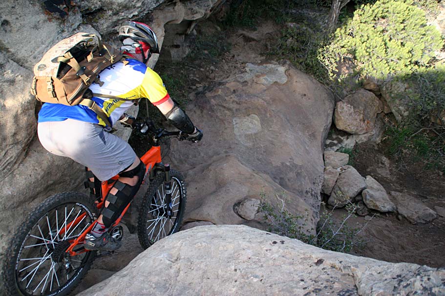
(Nichol looking out from Fence Point)
Now between an overuse injury and an illness I had been off the bike for a two solid months. The injury was (and still is) tendonitis in my elbows. I had been trying all kinds of things but rest and all I really managed to do was make it worse to the point where it was not only painful to steer the bike, but painful to do all kinds of daily activities. Just about when I was ready to get back on the bike I came down with some nasty flavor of the crud and that kept me off the bike for another couple of weeks. I’m going to call it a blessing in disguise for my elbows. So the following morning when we headed out on the trail the general decline in fitness along with the trail undulating between 7,500 and 7,750 feet was quite a wake-up call for this sea-level slacker.

The good news for me is that the Rainbow Rim trail is not a trail to be bombed. If you come out here to work on your Strava time you are an idiot. This is a stop and smell the flowers kind of place.

We split the Rainbow Rim trail up into two days. On the first day we did an out and back from camp to Parissawampitts Point for a total of 18 miles. I was dragging by time we got back to camp

A killer little meadow

I think aspens are one of the pretty trees there are and I really like how they are intermingled along the trail with the large pines.

MEAT! Big fat cowboy style T-bones cooked over a campfire about 20 feet from the rim. Life is good! There were only a few hours between sunset and moonrise but in that time the stars that could be seen were crazy amazing.

The following morning we did an out of and back from Locust Point to Timp Point. The trail in this direction was just as awesome as the previous day.

Once again, I’m a sucker for aspens.

Lots of wildflowers out showing off

When had some of the locals out watching us.

When we got to Timp Point, I wanted to show Nichol the Thunder River coming out of the side of the canyon. I thought I was looking in the right direction but was quite befuddled.

It was not until after the trip when I reviewed my photos from the 2010 that I figured out my mistake. The photo above is from the 2010 trip. Notice the slightly different angle of the “slot” of the canyon in the above shot and the one of it from this years trip. I had forgotten that we hiked down a trail at Timp Point that goes further out onto the point. It sheds off quite a bit of elevation, but you have to do this to get the right angle to be able to see further down into the canyon that reveals Thunder River.

Here is a zoomed in shot of Thunder River. Those are not bushes but trees!
There is an 8-mile extension of the Rainbow Rim trail in the works. It will consist of 3 miles and change of new singletrack and a decommissioned forest service road will be converted to trail. I rode about 1.5 miles or so of the roughed in new single track beyond Timp Point before heading back to Timp Point. It will be a sweet extension when complete. The cruise back to Locust Point was just as awesome as the outgoing leg and the chunk of the extension I did brought the days mileage up to 21 miles of coolness. We had another lovely evening and we casually broke camp the following morning to start the road trip back to San Diego. This was such an awesome trip and well worth the effort to get out here. This will not be my last time out here.
Wildfire threatening the SART

There is a wildfire burning near Angelus Oaks, Barton Flats South Fork Area. Hopefully they can keep this contain south of HWY 38 and protect the homes in the area. It would also be a horrible for the Santa Ana River Trail or Wildhorse to burn. Major Bummer!
LAKE FIRE UPDATE AS OF 6/19/15 @ 0658 HRS:
The U.S. Forest Service is reporting that the Lake Fire is now at 11,000 acres, with 10% containment. There are currently 1,224 personnel battling the blaze with the following resources on scene: 88 engines, 1 air tanker, 10 helicopters (including night-flying), 1 air attack plane, 28 crews, 3 water tenders, and 1 dozer. Additional resources have been ordered. Highway 38 remains closed from Angelus Oaks to Lake Williams Drive. The Big Bear Sheriff’s Station will continue to provide updates as information becomes available.

You can follow along with the progress of the firefighting efforts here
JUNE 22th 2015 UPDATE
The fire has burned 17,305 acres and is at 21% contained. If the trends continue in their current form, the Santa Ana River Trail is going to be spared from any fire damage. Currently all hiking trails into the San Gorgonio Wilderness and the Pacific Crest Trail from Whitewater Preserve to Onyx Summit are closed.
JUNE 29th 2015 UPDATE
The fire has affected approximately 30,716 acres in size and burning in timber. It is now 50% contained. Highway 38 has been re-opened, however all areas affected by the fire remain closed to recreation purposes.
Beautiful Scenery at Laguna Meadow
This past weekend Nichol and I did some camping up a Big Laguna Meadow for a couple of days of enjoying the trails in the area.

The last bit of rain we had did the flora some good and it look downright like spring up here.

There was plenty of color both out on the meadow and in the trees.

Some pretty white stuff on the Big Laguna Trail. This particular section is one of the reroutes from a couple of years. I said it before but once again, thumbs up to the ranger out here was made it happen.

Some color on the upper section of the Noble Canyon trail.

Lupines near Wooded Hills.
If getting out to Laguna Mountains has been on your to-do list for a while now is an excellent time to get out there!
Utah Weekend – Little Creek Mesa
Our last day of the Utah weekend found us rolling out of the hotel at a pretty descent time and headed out to Little Creek Mesa with a pit-stop at River Rock Roasters for some caffeine and sandwiches for a mesa-top lunch. I have ridden Little Creek several times before and this place is just great. It has pretty much everything I want in a trail. There is plenty flowing singletrack with technical goodies. Huge vistas that start right at your feet , rock slabs to play on with features big and small, and nature’s beauty all around you. It also has a feel of being far and away and the route finding you have to do (even with the aid of a GPS) offers a kind of mental engagement that I love in a trail.

We started out on the main loop and soon found ourselves playing on rock slabs with Zion National Park in the background.

With all of the rain over the last handful of days there was plenty of water pooled up in the depressions in the rocks. The big rock slabs gave way to forested single track that was just awesome with the fresh scent of moisture.

I was not expecting to see snow on the mountains west of St George. I just don’t see how the views from this mesa could ever get old.

“The Hot Tub” along the western rim of Little Creek Mesa. This was one helluva spot for snacks.

The rain had lots the cacti blooming.

Better to look than to touch.

The main loop took out to the fork for the North Point loops. There are some sweet bits of single track goodness as you head out to the North Point with Gooseberry Mesa typically in the background.

I had ridden this thing a couple of times before but failed to notice the gap this slab went across until this trip. I guess I was too focused on where I was going.

The same gap after it opens up a bit. What an amazingly gorgeous day! Once back out to the main mesa we enjoyed a bit of route finding as there seemed to be cairns here, there and sometimes seemingly no where. You could play out here all day.

Our playing around eventually took us to “The Waterfall”, one of the iconic features of the mesa. This was my first time doing the waterfall with actual water around. I dug how the water showed the line I took. The dark line on the slab is the rear tire while the much fainter line to the right of it is the front wheel. Here is a shot from a previous trip that shows the led in. We took the Magic Carpet Ride trail back to the trailhead. After leisurely enjoying some refreshments and more snacks we had to lament about the reality of still having day jobs and the continual puzzle of how to grow old without growing up. Considering that we spent that last few days playing in the dirt and riding bicycles we had scored points for neither growing old or growing up this weekend. That shit would have to wait until tomorrow.
Utah Weekend – Boy Scouts & Zen
We woke up on day 2 of our Utah weekend to find that it had rained most of the night. After consulting with the folks at Over The Edge in Hurricane, we changes our ride plans for the day to kept from mucking up the trails. We went out to the Quail Overlook Trail System which is beside the Quail Creek Reservoir. Colloquially this place is known as the Boy Scout trails due to a nearby Boy Scout camp.

Oh my this place put down some techno-spank right out of the gate that included tight rocky single track with plenty of “power” moves.

The trail system primarily includes four loops on three sawtooth escarpments.

The builders have done a super job of laying out the system to maximize the use of a rather small chunk of land.

This place is advertised as an expert level trail system and I can’t argue with rating, but I will clarify it. This is a “slow-tech” wheels-on-the-ground playground. There is not a lot flow here and it is not a bad thing, its part of the character of that place that just seems to pack “It” into the miles.

I particularly enjoyed the combination moves. Things like a rocky climbs with ledge moves coming out tight switch backs. There were plenty sections where you seem to be continually in a state of using body English.

The most northern loop called Adventure Scout was by far the most technical of the bunch out there. We ran into one of the primary builders of this trail system (Quentin – – Awesome Job Quentin!!) and he described a couple of sections as best ridden “Balls over Brains”. It is interesting to note that not following that advice could have you literally going “Balls over Brains” into some very unforgiving terrain. There is a lot of effort per mile designed into this this place. We only did a little over six miles and it felt like we had done twice that. I really dug the combination of power moves and the bit of mental “checkers” required to clean the stuff out here.
As we enjoyed a tasty smuggled in San Diego microbrew over lunch, we decided that we had enough gas in the leg tanks for an afternoon session.

We hit up The Zen Trail which is right on the outskirts of St George. I had heard lots of good stuff about this trail and it has always been on the To-Do List but have never gotten to it.

Things opened up with a climb and soon we were near the edge of the mesa.

There is about a total of 1,100 feet of climbing on this route. We could see ominous clouds slowly moving our way.

The variety of this trail is quite awesome. Rock crawling, sweet single track, vista, there are lots of goodies out here.

When we got to the top of the mesa we had some great views of Green Valley below. We could also see the rain a coming! Shortly after the picture above, the rain caught us and the camera remained holstered in my pack. The descent was exceptional with a combination of sweet single track and with some slick rock. There were also a few undulations along the way that put a little sting in the legs at this point in the day’s overall effort. We also missed a turn and found ourselves on double track. After a bit of uphill backtracking we hooked back up on the single track that lead us back to the trailhead.

Just as we were getting back to the truck the rain stopped and the sun broke out. Ahhh rainbows and microbrews from heaven. We were living well!
Utah Weekend – Guacamole
This past weekend Bill O’Neil and I made a dash to Utah to get on some good red dirt and killer rock riding. We were quite surprised that a storm had settled in the SoCal area the night before and brought in some much needed rain along with some snow at the higher elevations. It was a mighty fine time to get the hell of Dodge. The destination for day one was the Guacamole trails perched up on a mesa outside of Virgin, Utah. After copious amounts coffee, beef jerky and a tank and change of fuel (burned at a highly uneconomical rate), we crossed into Utah to be greeted with storm clouds. As we rolled through St George and Hurricane we were intermittently getting rained on but I had learned that in this neck of the woods if you don’t like the weather wait five minutes. As we rolled through Virgin there were clear skies above and the dirt road that goes up to the mesa had just a puddle or two.

It was a bit brisk and windy but beautifully sunny when we rolled out onto the first trail segment called Margarita. This was a new trail to me and I was stoked to check it out.

It was not long before we juked onto the Salt on the Rim trail and got in some good views along with the sight of incoming weather. Someone in Seattle once told me that there is no such thing as bad weather only bad gear. We had the gear, but from the best we could tell it looked like this storm would pass us just to the south.

We did end up get a little sprinkling on us as we made our way out to the main Guacamole Loop but it only lasted a few minutes. What we were left with was straight up hero dirt.

We took a connector trail called Lime (These trail names rock!) that went out to another loop called Holy Guacamole that took all the way to the southern tip of the mesa. We had good views of Zion Nation Park as well as the north rim of Gooseberry Mesa from here.

This is some fantastic single track with good technical challenges through amazing landscape with Zion National Park just a stones through away.

In several spots the trail is literally along the park’s fence line.

Holy Guacamole this is a fun trail!

The Holy Guacamole goodness brought us back to the other side of the earlier loops we were on that eventually took us back to the trailhead. This was some grade A trail awesomeness and it will certainly not be my last time riding on this mesa. Shortly after we got off the mesa and headed back to St George we got into a good bit of rain. We were pretty stoked at our window of fortune with the rain and we were particularly glad we had decided to get a hotel room for this trip vice our typical camping arrangements. It was a mighty fine start to the weekend.
Orosco Ridge – Boden Canyon Loop
I have added a page to the site for the Orosco Ridge and Boden Canyon Loop near Ramona. This is 14.2 mile loop that includes about 2,200 feet of total climbing.

An old road/truck trail turned singletrack through a meadow in Boden Canyon.

Mother Nature is doing good stuff to the Lower Santa Ysabel Truck Trail.

This old road in Boden Canyon has turned into some singletrack goodness. Check it out!
Cool Critter Encounter
Sunday I did an MTB ride-along with San Dieguito River Park Senior Ranger Dave Hekel. After my recent Coast-to-Crest Trail trip I had some questions about the park and tagging along on his Sunday patrol was an easy what to chit-chat about the park and get in a ride. I ride Lake Hodges quite often as of late. It is right on the way home so it is in the routine post-work ride rotation. I have seen lots of critters out here on these trails. Deer, snakes, coyotes, rabbits and all kinds of birds. On this ride I ended up with a critter encounter of completely different sort.

While riding the “high road” single track on the north side we came across an obviously distressed little coyote pup stumbling across the trail like a drunken sailor. After a quick look around the hillside to see if mom was anywhere nearby, I scooped this critter up. It was tiny and whopped and did not resist in the slightest to me picking it up. A quick scan showed that this female pup was not injured but had pretty big tick in one ear. Dave went up the canyon to see if there was an unattended den but could not find anything. We guessed that this little gal had been away from momma for a least a full day or two.

Talk about camouflage. Look how the coat is a spot on match to the hillside in the background. While Ranger Dave made phone calls I gave her some water. I took the top off of my water bottle and turned it upside down and used it as a small bowl. She drank quite a bit of water and it seemed to help as after about 5 minutes she would have a spat of being squirmy. I’m thinking instincts were telling her to get away. I found that if you held her close to my chest she would stay calm. (Much better than the one-handed holds for posing her for the camera)

(Whooped but still a cutie)
While Ranger Dave was getting all of the arrangements made quite a few riders came by so the this pup because the star of trailside show and tell session.

(Check out how long those claws are for its size)
Soon the rangers had a plan. I rode/walked the rest of upper singletrack with this pup nuzzled up between one hand and my chest to a meet up spot with another ranger with a truck. While Dave and I waited for the other ranger to arrive the pup feel asleep in my hands. There was a point when we wondered if she had “checked out” but then I could feel her chest going in and out so things were good. Once the other rangers arrived we handed off the pup to them and they were off to a nearby wildlife recovery facility.

After that we went off to finish out the rest of the patrol. We did encounter a rattlesnake on the trail and I did a slight bump stop into the back of Dave. Normally seeing a rattlesnake is kind of a big deal but considering that this was the 14th rattler I have seen this year (I typically only see 2-4 a year) along with the coyote pup just a little while ago, this rattler sighting was kind of ho hum. It was a beautiful day but after the coyote pup and the rattler then return trip back the ranger office was uneventful. This was a most excellent day to be out on a bike and reinforced to me that your next life enriching event could be right around the next bend in the trail.
Mule Hill – San Pasqual Valley
I added the Mule Hill and San Pasqual Valley trails located near Escondido to the site. You may also hear these trails referred to as Raptor Ridge as that is the top of the climb. While this is for the most part a non-technical trail, the farmland scenery not typically associated with San Diego it offers is worth a look-see.
