Flagstaff Sampler Pics

Got back from Arizona last week and I have a ton of pictures from this awesome trip to sort through.

Here are a few pictures from the first half of the trip in Flagstaff.  All of our riding was done above 7,000 feet of elevation so there was plenty of huffing and puffing on these rides.

Aspens and log rides…There is a combination. Jeff showing how it is done.

Cowboy TV and board meeting to plan out singletrack domination

Dell checking the air pressure in his tires.

Art23RockPile enjoying the finer things in life.

I’m such a sucker for Apsens. Art crusing through.

Bill O’Neil rolling along.

Steppie telling us again that he would be surprised if there was a 1000 feet of climbing on this ride.   (It was more like 2-3000 feet)

From campsite most of the rides started with a cruise down the Schultz Creek trail. It is like having ice cream for breakfast.

Craig enjoying the thin air.

Art playing on the Washabi trail

The was some sessioning done on some doubles. Jeff

Dell

Craig

Art on a nasty section of Private Reserve

Craig also playing on Private Reserve

Dell on Pickle.

Bill O’Neil on Pickle

The full story to follow…

The Maunawili Trail

This past Saturday was the last day on my Hawaii business trip and I was able to carve out some time on Saturday morning for a ride.  The destination was the Maunawili Trail on the windward side (east) of the island.   I got an early enough start that I had to casually get ready at the trailhead while waiting for daylight to join me at the rally point.

The Maunawili trail is a 10 mile singletrack that countours along the foothills above the Maunawili Valley and near the striking cliff bases of the Ko’olau Mountains.   All of the descriptions of this trail I had found recommended it as a point-to-point from the north end near the Pali Lookout and going south down to the community of Waimanalo.  There was only about 1,000 feet of elevation between the high and low points so that even accounting for some undulations in the trail it should not be too bad as an out-and-back.   The sun did not make a majestic entrance when I started out from Waimanalo.  It was quite cloudy when I set off on the double track climb that would take me up to the start of the trail proper. 

The doubletrack was not horrible, but the singletrack was downright awesome pretty much right from the get go.  Sweet narrow goodness etched into steep hillsides was the theme most the time.     While most of the trail tread is smooth, there were numerous rooty and rocky section to keep your technical skills on point.

 The trail went in and out of numerous foothill fingers and while the cloudy morning was putting a damper on the full beauty of this place it was still impressive.   The prominence of the cliffs often made me feel downright small. 

The beauty of this trail really did a good job of hiding the danger of the steep hillside that was often less than a foot off the trail thread.   If this was a barren desert trail, it would be easy to get wigged out about some of the exposure.    Mother Nature added to the deception and danger of some of these spots with ferns that grow in from the high side of the trail.   I preferred having my faced brushed by ferns over finding a weak spot on the downhill edge of the trail. 


 The  flora on this trail was simply incredible.  I only knew what a few of the types I saw where.  Later on I found out that I had been cruising under cool stuff like mango trees, pink guava, a plethora of ferns, and a bunch of native plants that contained way too many vowels for me to pronounce.

As I started nearing the north end of the trail, there was more signs of use and well as trail maintenance.   In some of the wet spots a few boardwalks had been installed to help the trail and habitat keep from getting thrashed.  At this point one thing was for sure, this trail is uphill in both directions.     It took me a lot longer than expected to cover the 10 miles and reach the north end of the trail at Pali highway.    The plan was enjoy the trail in other direction, but I did not have enough time now as I had after lunch work commitments.   With a great deal of reluctance, I played grown up and dropped off the mountain on the road and speedily made my way back  to my car.   The work went well, but I did have to burn some “lamp oil” to polish everything off.   One thing is for certain, this will not be my last ride on this trail.  I’m already looking forward to a sunny day return…someday.

Aloha from the Aiea Loop

I love it when things just fall in place.   I had to “work” in Hawaii this week and was hoping squeak in a ride during the trip.   I had a early flight on Tuesday and found myself on the ground at lunch time.    There was no delay in getting my baggage and the rental car thing went really smooth.   I already knew where I was renting a bike during this visit so went by there picked up and decently equipped hardtail that was basically brand new.   It was right about this time that I realized that I forgot to bring my clipless pedals.    Cleated bike shoes and flats pedals don’t mix well so my next stop was to local bike shop where I picked up a set of SPD pedals on the cheap.     I was all set to squeak in that ride when the opportunity presented itself.   A look at my watch revealed that opportunity was now and the trailhead was just a few miles a way.  The sky was filled with ominous looking clouds but what the heck, the temps were nice and it was not raining right now so time to get some trail while I can.

I had done the Aiea Loopbefore which was good as I did not have much of a daylight buffer for exploring.    Having all much my gear stuffed into luggage it looked like a yard sale around my car I was pulling stuff out all over the place to get to everything.   Soon I was in the correct garb and ready to head out.    The last time I rode here was in 2004 and I remembered lots of roots.  Yeah lots of roots.   Back in 2004 this trail was my first exposure to roots galore and I remembered it being monumentally frustrating.    Since then I have had a lot more exposure to riding this type of stuff so the roots where down into the challenging category. 

For the first 1.6 miles of of this loop you are climbing some good and twisty singletrack.   I have been fighting off some chest and sinus congestion for the past week so the “redline” on the cardio side of the house was much lower than normal.  Get anywhere near that line for line would quickly turn into a wheezing, hacking mess.    This meant I really got to enjoy the climb as despite the overcast, the scenery was nice with lush vegetation all around.  


That lush vegetation however does hide some often precarious exposure that could net you a long tumble down a steep hillside should you blow a move or turn.

Once I reached the highpoint , the fun really got to going as a good chuck of the rest of the route was downhill.    The flowing singletrack typically bench cut in the side of the steep hillsides so there was little room for error along the trail.  I had gotten into flow of the trail and was zipping along quite nicely when the bike gave me a quick reminder that it was not one of trusty full suspension bikes.  I took a root drop that was a little bigger than it looked from up the trail and soon found myself riding a compressed fork nose wheelie for way too far before slamming the rear wheel back and nearly jolting myself off the bike.   After getting the bike to a stop, I starting laughing so hard that I sent myself in another round of congestion hacks and coughs.    Any near miss that you can laugh at is good in my book.     

It was not long before I was back at the trailhead where I cleaned up a bit and did the yard sale thing in reverse and headed out for the hotel.  What a great way to start a business trip.

“Taiiku no hi” Ride

 This past  Monday was Columbus day in the United States, but I’m not in the States.  Lucky for me Monday was also the Japanese Holiday of  “Taiiku no hi” which is “Health-Sports Day”.   What better way to celebrate that than a bike ride. 

Fall is happening here.   The summer heat is gone and the cooler temps of fall have taken over. There are no huge splash of colors just yet but you can tell that mother nature is dusting off her brushes and shaking the paint cans.

The closest mountain to town is Yumihari.  I have been on most of the flanks of this mountain and have found some stuff to ride in all those areas.   The place suffers from little use and even less maintenance.    This place would be incredibly awesome if there were enough riders to keep this place debrushed.  I was focusing on the southern area today and was quite pleased with what I found and that it is seeing some use.   One such trails was an awesome benchcut along a ruggedly steep hill side.

I eventually found my way over to what I was looking for.  There is a large statue that you can see from town perched up along the ridgeline that I had been eyeing from work for a couple of weeks now.    This thing is huge.  At least 20 feet high and it sets top of 20 foot raised base.  This was a great spot for some snacks so I enjoyed them while taking in some of the views. 

There was an old couple there tending to the grounds.  Eventually the husband and I struck up a conversation which was a mixture of my bad Japanese, his bad English and a healthy dose of International Charades.   From the jest of the conversation, the man was 70 years old and his father made the sculpture.    He was very proud of his father’s work.  He was also proud of the fact his wife was much younger than him (only in her 50s).   The wife snickered at this and gave him a gentle slap on the arm.  While I did not catch what see said, the facial expressions translated to something along the lines of “You Dirty Old Fool”.  While he looked old, he was mighty healthy and was doing some significant work like cutting grass, trimming back branches, etc…   I hope to be that spry when I am his age.  You can tell they loved and cared for this place.    After a bit more broken chit-chat over a can of coffee he gave me, I was on my way.  After such a nice little life enriching experience I could have called it a day right then and have been quite happy.

Lucky for the me the old man had “Charaded” me some more information on trails, so settting off from the shrine, I did some more snooping around.

What the old man had pointed to was a really cool bit of trail where you descend down along a mostly steep ridgeline through a forest of mixed bamboo and hardwoods.   It was a pretty fun descent with some scary bits thrown in when things got rocky and really steep.  

After this I climbed back up the mountain and hit some one the loops I have done several times which put me back onto the side of the mountain I wanted to be on.   After another rather technical descent I popped out into another neighborhood.   From here I zipped along a series of narrow twisting sidewalks that descended the rest of the way down the mountain back into town.  I love when the navigation calls for anyway that is downhill to get “home”.    I might get another ride or two in before I leave Japan but if not this would be a downright cool closer ride.

Tooling around the Tawaragaura Peninsula

Yesterday, I decided to check out the peninsula to the south of Sasebo.  The plan was for this to be road ride and be on the lookout for some trails to explore on another day.  I was actually looking forward to a ride where I did not have to deal with the arachnid gauntlet of webs across the lightly used trails around here.  Last weekend, I must have taken 50 spiders to the face and it got old.

Peeping around on the online maps it looked like the peninsula was gong to be “country” so I packed plenty of snacks.  Onigiri is my favorite ride snack in this parts. It is a triangle of rice with some type of filling on the inside (I dig the tuna) and whole thing is wrapped in seaweed. 

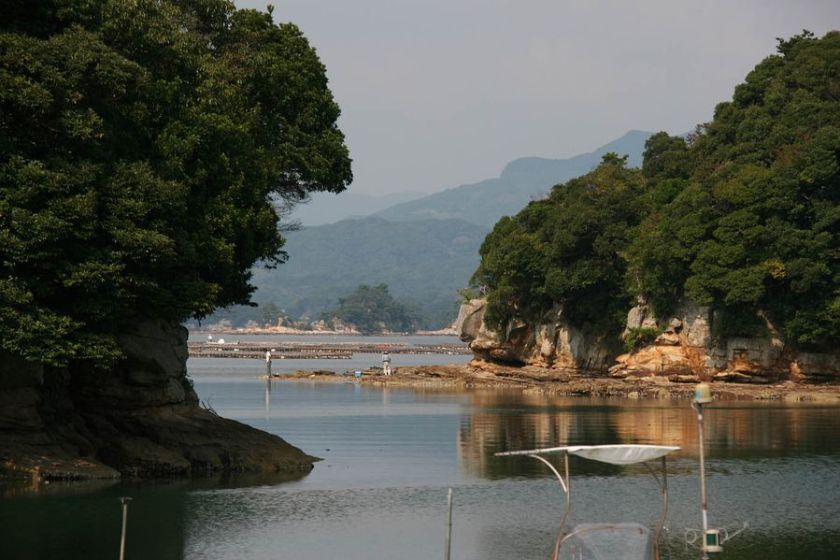
After a bit of hilly road work I got to a pretty cool park overlooking the “99 Islands” area.  The islands are quite pretty and as you travel around there are every changing views as your angles to the numerous islands change.

The main road I took while heading out on the peninsula stayed up on the ridgelines for the most part.  There are quite a few old farming roads that head down to the various nooks and crannies along the shoreline.   Many of these roads are much more narrower and far more interesting that most of the “Trails” built by the various land mangers in San Diego County.


While humping back up one of these old roads, I came across another crab.   While I’m only a couple hundred feet above sea level here, I was still amazed to see them up this high.  I did a little research and found out that the crabs here have adapted to living away from the tidal range so you can find them all over.   Like the one I saw last week, this bugger did not like having me around.  He did manage is get some pressure on my thumb through my glove and I must say that this little guy has got quite a pinch. Doesn’t he look pissed?

As I ventured further out towards the end of the peninsula I found the roads turned away from the southern tip.  I managed to find an old road bed turned trail and decided it was worth a look as it would keep me working my way south.    I learned a spider sweeper technique for riding around here.   I take a nice green stick about 3 feet long and keep it between my right hand and handlebar grip.   When I see spider webs I sweep the stick around out in front of me.   It works well when climbing non-technical stuff, but not so much when descending or in technical stuff.   Of course I look like a crazy mashup of  a mountainbiker and an orchestra conductor on crack but what the heck the spider thing gets old after a while and this lets me keep moving. 


The old road bed led me up to what I believe is a series of old WWII bunkers.  (I have yet to confirm this, but I am told there are nuemerous ones in the area) Some of them are dug into the side of the mountain while others are dug down into the mountain.  They were really trippy.   This was the biggest one with five interconnected bunkers dug into the side of the mountain right at the summit. 

This was one of the ones that was buried down into the top of the mountain.


When I was in the large interconnected bunkers, I was not alone.  There were some bats that called this place home.   When I got too close that started flying around and moved into the adjacent bunkers.  Since I had started at one end by the time time I got to the last bunker, they were all concentrated into the one room.  They did not want to go outside and since I was standing in the archway between the rooms, they were a little perplexed.  I spent a lot of time working on getting a shot of these little guys.  They would often buzz within a foot of my head as they thought about going past me to get to the other room.   The camera flash usually sent them wheeling around away from me.

This is the best closeup I was able to snag.  Ain’t he cute?   I heard this species is closely related to the endangered Texas Perot Bat.

After harassing the bats for long enough, I continued along my way of poking around on the peninsula.  There was lots of farm patches up here as well as a small community.  Looking back to the north I could see pretty much every peak I have gotten to so far in Sasebo.

I decided to drop down to the Shirahama Beach were I was expecting to see hordes of Japanese hotties in bikinis.   I had to settle for nearly having the beach all to myself while enjoying an onigiri and views of the East China Sea. 

The water looked inviting but you would have to watch out for these critters which were in abundance.

I spent quite a bit of time checking out some of the nooks and inlets. I’m sure some are only accessible via boat.   I took lots of notes and waypoints of the many old abandoned roads and nearly overgrown trails that dot the area.  I have enough dots and dotted lines for a return visit.

I got to a road junction where I could take the fairly direct route back, or I could take the more round-about way back along a big eastern chunk of the peninsula I had not gotten to yet.  Thinking that I could stay down along the shoreline I took the road downhill into a small fishing villiage.  I really like these small seaside towns, I feel like I’m closer to the culture when in places like this.   I dig watching families fish, old couples tending to thier crops or just strolling along the narrow coastal streets.  The people are so warm and friendly particularly when you know enough of the language to exchange basic greetings and be polite.   When you look on the maps the peninsula is listed as Sasebo, however the three or four folks I talked with on this ride all asked if I had came “from” Sasebo.  Clearly they don’t think of thier quite little neck of the woods as Sasebo and now, neither do I.   The ride back along the more scenic route was anything but the flat cruiser shoreline ride I had expected.  Between the little fishing villiages the road would climb back up into the hills and then drop back down at the next village.  I don’t know how many undulations I went through but by the time I got back to the hotel I was throughly pooped.   It was a good day on a bike.

Added Takatori to the website

I finally got all my notes, photos and map information together for the Takatori-yama area near Zushi and Yokosuka, Japan.   I added a Google Earth KMZ file to this review that is mashed up with my photos and trail notes  as well as Japanese topo map to help you get to know the area better.  One thing I like about this setup is that you can find all sorts of other information on the area in addition to photos from other people.  If you find yourself in the area you should definitely check this place out.  For all my peeps on the Far East Side that call this place home, keep the trails ridden and shot me some more information on the trail spurs I did not get to.

The Takatori-yama Page

More sights from around Sasebo

Okay for the last week or so I have been getting hammered at work.   I’m doing lots of writing but it is not about Mountain Biking.  Such is the nature of “work” sometimes.   I have managed to get out and find some new stuff and experience some more of the culture of Sasebo.   Here is a quick recap of the last week or so of my off-time in Sasebo.

There is plenty of terrian to play with here….finding the goods is tricky, but it is “coming along”.  Sometimes coming along means clearing old trails yourself.

When doing just that on one of the trails, I flipped over a rock and to my surprise this guy was there.  I’m a good 3 miles and 1,000 feet above sea level so I have no idea how “Mr Crabs” got up here.   I’m wondering if this guy has some “Finding Nemo” like story to tell.   One thing is for certain, he was quite a curmudgeon and was trying to get rid of me.   Thumbs up for full-fingered riding gloves!

I wonder how old Mr. Crabs would fair against this guy?  Lucky for Mr. Crabs this is a Japanese Rat Snake.

The food chain in action.  It is family dinner time at Charlotte’s house. 

I found a really old timber road up to the summit of Mt Syoukann.   So far this is the longest bit of climbable dirt I have found that did not include some hike-a-bike.


A real bonus was a pretty cool singletrack going down the other side of the Mt Syoukann that combined with the old road makes for a nice bit of riding.

Mount Eboshi is becoming a regular stomping ground for me but I’m still finding  bits of trails here and there to add to the riding inventory.

Mt Kaku is a bit bigger and west of Mt Eboshi.  It was a bit of work to get over to it and the final half a kilometer was a bit of beater hike-a-bike.    A snack and a little basking in the sun were well earned when I got to the summit. 

This trail coming off of Mt Kaku was a real treat.  This is a fairly new trail that shows some modern trail science applied to its design and construction.

You don’t have to get out on the trails to see cool stuff.  The city has lots of interesting stuff to see.  These Japanese carp are pretty fish and are plentiful in main river through town.

I came across some folks praticing a “Dragon Dance”.  It is some pretty intricate stuff they do.  There are 10 people working the dragon, conductor as well as about half a dozen kids playing various drums, gongs and bells to put it all together.

I watched them practice for about a half hour in the small park/court yard before strolling back to the hotel.

The sun is up and I have a day off….It is time to ride.

Exploring Mt Eboshi near Sasebo

Mount Eboshi is the most the promeint mountain surrounding Sasebo.  So of course I had to go up there and see what the deal was as I had been told there are trails up there.  I had even been given a very rudimentary map.  During my first visit I realized the map was pretty outdated and soon was relegated to remain in the pack as backup mountain money.   Luckily there were a few trailhead maps that I was able to key off during my second visit and things started coming together (sorta).

This is pretty much your average trail look near the top of the mountain.

Ready to get your chunk on?  (Yes this is the trail)  This this is pretty much the most extreme section of trail in the area, this type of rock is found interspersed along the trail and provide some nice character and features.

While stopping to smell the flowers this critter came along.

Check out this lookout/rest stop.   Look at this angle on the benches.  Does that not just scream, “Take a load off, lay back and relax”.

A skinny little bench cut that reminded me a bit of the SART.  It was one of my favorite and longest sections.  There is a lower section to this trail that appears to be rarely used that was also superb but suffered from some deadfall.  I spent some time and cleared the stuff that could not be ridden over.  I was hoping to see it continue on down the mountain but it stop at a road instead of crossing it and continuing onward.  Bummer.

Sort of a hazy view from the summit of Eboshi.   There are three trails going up to the summit, one is pretty mild, one looks nasty, and the other I have verified is a hike-a-bike pain in the arsh with just a merger 309 steps on the final section to the top.


Yes I counted them and even took notes  — I didn’t have a pen 🙂

A view from coming down the south side of the mountain.

While there is are some nice sections of trail I have yet to find a good trail that cashes out most of the four plus miles of climbing it takes to get up here on the road.   Most of the trails are up on top and none of the trails I have found go more than a third of the way down the mountain before dumping out onto roads.  I have found remnants of trails but the pace of Mother Nature’s reclamation program there just does not seem to be enough use to keep some of them from becoming overgrown.   With a few or so seasons of TLC  this place could be a far east MTB mecca quality playground.   More to follow…. 🙂

Snooping around Sasebo, Japan

So work has taken me back across the International Date Line for some more adventures in Japan.  This time I am in the south of Japan in the city of Sasebo.     The work is interesting with some new challenges to keep me on my toes.  I even have run into some old freinds from San Deigo who are calling Sasebo home these days.   What was really cool upon arriving here were all the freaking mountains I saw on the drive from the airport to the city.   Forested ridgelines that seemed to go on forever was pretty much the norm.  Early last week, I snagged a rental and have started snooping around.   With promenant peaks in just about ever direction there is plenty to explore.   There is not much of a organized scene here MTB wise, but there is a culture of hiking and what I would call “Micro-National Parks” in the area.  

This past sunday I checked out some of the in-town mountains.  There was quite a bit of road interconnecting to get to the trails but I think it was worth it.  This is an exceptionally pretty area so it was more like a tasty road-touring cake with some yummy dirt frosting on top. 

The view of the a small slice of the “99 Islands” from Mt Ishidake.

Zippy along the trail on Mt Akasaki.

Hmmmmmmm, where to go next?

The chunkier route less followed.

Brushing this out of your face along the trail is kinda cool.

Brushing these off your face is not so cool.  They get about as big as a silver dollar and while harmless they can freak you our when you get “Bulls-Eyed” right in the face with them.   This has happened more times while riding in Japan than I can count.

One of the mountains within the city limits of Sasebo is Mt Yumihari.  It is sizable and the roads are a bit steep.  While I have been on Mt Yumihari a couple of times already, there is no real trail system but more a like series of not quite connected trails.


Still there appears to be plenty of stuff worth exploring.

There are some stunning views from the summit, but I thought some of the more interesting bits were off in the back corners and the not quite so accessible spots.

This little spot about several hundred meters past and a brisk climb from all the parking lots was absolutely empty and made a pretty tranquil spot to chill and knock back a snack.

I recognized this as soon as I saw these as they were also near Mt Takayama near Yokosuka.   This is the basement foundation for a anti-aircraft gun battery used during World War II to protect the port of Sasebo.   I could not help but think what must have been gone through the minds of the soldiers manning this battery on August 9th 1945 when “Fat Man”, the second atomic bomb, was dropped on Nagasaki just 30 miles to the south.   On a clear day they would have had an unobrstructed view of ground zero and the mushroom cloud that reached upwards of 60,000 feet.  I’m sure they must have felt and heard it for sure.   Talk about being a witness to history.

There was this faded sign nearby.

By this time I was getting pooped and the my daylight buffer was getting a little short for full blown by myself and unaided by maps exploring.  I went down the mountain on a new route that included an extremely narrow one-lane paved road and took notes on all the various trails heading off here and there to be snooped at on another day.

It was a great day on a bike and I slept like a baby that night.

Updated Fugato-yama Japan Page

I have finally got my first of what I hope to be half a dozen a or so updated and new Japan trail pages up.  The Fugato-yama (aka Ghosttown” area is a really cool trail system that I have yet to fully get into each corner of yet.   The updated page reflects a bit of work left to be done as far as the trail information goes. I highly recommend a GPS for riding this area unguided for the first time and I have included a bunch of electronic data to help with that effort.   The primary file is a Google Earth KMZ file that includes a topographic map overlay that I created using data from the Japan Geospatial Institute.   Additionally most waypoints in the file also links to trail junction photos I took while playing around out here.   I hope this will be a useful tool for my peeps who visit the area.   

Updated Fugato-yama webpage