Florida Canyon in Balboa Park

So I was tube locked for most of the day on Wednesday, but an appointment near Balboa Park gave me about an hour and half to squeeze in a quick ride in Florida Canyon.   Florida Canyon is part of Balboa Park and the canyon has trails on both sides of Florida Drive which goes down the middle of the canyon.   I have only ridden here once before about 13 years ago.  Besides that there is not much mileage out here I had forgotten my other aversion to this place.  I was obvisously overdue for a refresher.  

FloridaCanyon-06MAR13-03

While this place is very short on miles, the fact that it is bascally in downtown gives it huge bonus points.   The place is pretty and has enough ups, downs and turns to keep a beginner excited.

FloridaCanyon-06MAR13-04

Most of the trails are about sidewalk wide and while being solidly in the none technical category they do have some character here and there.  These trails are much better than the homogenized decomposed granite sidewalks that are so prevalent among most of the city and county created pathways/roads that they try to pass off as “trails”.

FloridaCanyon-06MAR13-05

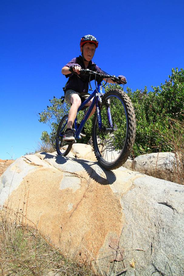
There are some more narrower singletracks here and there.  The picture above is of one of the trails on the east side of the canyon.   Now I am routinely prone to taking the trail less traveled to try and figure out an area’s trail system and today was one of those days.   While over on the east side of the canyon just south of Morley Field (highlighted in yellow below) I spotted a few exceptionally narrow looking trails that seemed to not see much action so I flicked the handlebars and headed off down the second one I came across.   Turns out I was quite wrong about the whole not seeing much action assessment.  Less than 40 feet down the trail I hear somebody coughing off in the bushes in a manner that seems like they are trying to get someones attention.  I thought it wierd but kept on rolling.   Around the next corner I see some things that well (a) Ought to happen behind closed doors (b) Joe Public should not have to see in a public park  (c)  Just can’t be unseen!    Everybody (Straight, Gay, Trannies, Furries, etc…)  has to get their freak on but come on!  I should have to type in some keystrokes like C: <INSERT> ### into my computer to see some shit like that on an idle Wednesday afternoon.  I was certainly motivated  get out of this section of “social ” trails at this point so I give some extra gusto to the pedals.   These little trails seemed more  like a maze and this point and two turns later I encounter a very stylishly dressed man in surprising uncomfortable looking shoes strolling along this little trail towards me.   (Don’t ask me why I noticed the shoes,  I just did okay.   I have been paying more attention to peoples shoes ever since I saw Shawshank Redemption.  We should all be slightly suspicious of people wearing inappropriate shoes.)    He was a cordial fellow who wanted to chat while I figured out how to get around him with the minium of greetings exchanged.     The guy seemed to pick up on the fact that Homee don’t play that pretty quickly and I was soon on my way again.    A handful of seconds later I popped back onto the main trail to notice another well dressed fellow reading a book while sitting on a log seat and another guy just sort of standing around.   Weird!

FloridaCanyon-Map-Highlighted

I then remembered why I had not been back over here in over a decade. Morley Field is a “Cruising” spot for gay guys looking to hook up for casual sex in the bushes.   To each his own but the Public Service Announcement for this trail system is

“Stay on the Designated Trails in Florida Canyon”   

Once I was back the main trail and checking out the rest of the trails I could not help but chuckle as dinner plans for the evening had already been made with my girlfriend.

FloridaCanyon-06MAR13-09

We had dinner at Hilcrest Brewing Company where they not only have good food but good beers as well.    Their pizzas are awesome and we had a tough time deciding between the “BBQueer Chicken” or the “Meatpacker”.   The Meatpacker won the coin toss and it went well my girlfriends  “Hoppy Endings”  IPA and my “Pearl Necklace” Pale Ale.   It was a very memorable bike ride with plenty of laughs and snickers afterwards.

Lake Calvera with Jake

With all of the competing interests pulling at my boys’ time such as friends, hockey practice, hockey games, etc…It was really cool that Jake wanted to join me on a ride at Lake Calvera this morning.

I took him on a different group of trails than what I have typically done in the past.  Some of it was due to some of the trails being closed by the City of Carlsbad as they have started actively managing thier slice of the Calvera “Area”.  Another reason for the trail change up is tha Jake has gotten strong and better on the bike so I thought it was time to take him on some of the more technical bits.

Jake did quite well on the technical bits.   I was surprised that the squeeze type rock moves gave him more troubles than having to go up and over rocks.

Which he seemed to find easy to just pop up onto and roll off of.  Makes me wish I had started riding a mountain bike when I was a little grommet. 

This trail feature should have a sign “You can be no taller than this to got on this ride”.  It would have been a face smasher if I would have tried it.  All together we did about 12 miles or so.

On our pedal back to the house we started thinking about tasty brown cold beverages for post ride refreshments.

Ahh, Coke Slurpees!

Anza Borrego Desert Winter Goodness

Against my better judgment, I’m going to join you.”  That is how this adventure in the Anza Borrego Desert started when Greg decided to get onboard with a bit of riding way out in the east county of San Diego.  It was late in the evening when we pulled the trigger to do a 28 mile shuttle run bright and early the following morning.   Pretty much all the information I had gathered on riding in this desert was that you have only a small window after winter and spring rains to ride unless you are into abusive sand slogging. Southern California just had a sizable winter storm that brought plenty of rain and snow to the area.   The window was supposedly open so it was time to go.    It was still dark when I started my eastward trek and when I arrived at the upper trailhead in the early morning light it was cold with a little snow on the ground.  It was a pretty winter scene in all directions.  I soon met up with Greg and we beat feet to the lower trailhead about five miles south of Ocotillo Wells. I wanted to be the trail at around 9AM but I had underestimated how long the logistics were going to take so it was just before 10AM by the time we started pedaling.

The first chunk of the climbing up Pinyon Mountain Road off of Highway S2 was not bad at all as the snow was not deep and the tire treads had created dirt lines in the 4WD trail. As we climbed higher the tire tracks became compacted snow vice dirt and climbing became more interesting.  As the snow became deeper, you had to stay right in the middle of the tire tracks other wise your pedals would strike the side of the groove and on more than a few occasions this started a series of pinball pedaling that often ended in putting a foot down in the snow.


As we reached the high point on the ride in the saddle between the Pinyon and the Vallecito Mountains at just under 4,000 feet the snow was a good foot deep.  It was a gorgeous scene and the snow riding was still not too bad.  We then came to an unmarked fork in the trail that was not annotated on the USGS topos or the park’s map.  After a bit of head scratching we came of with the theory that one of these forks is a dead-end and the other is the through route off the mountain.  We opted to go with the fork that had the most tracks on it.   Slightly downhill we went and after a quarter of a mile we were presented with a wonderful vista at the turnaround of a dead-end trail.   The reason this fork had more tracks was because there was two sets of tracks for every vehicle, one coming and one going. (This is Bill’s dumb thing not to do on the trail tip #276) The grade of this fork was just enough to make climbing on the tracks in the snow way too energy consuming so we hoofed it back to the fork.     

The correct fork turned out to be the path less traveled.  The trail only had maybe two or three vehicles pass through since the storm so the snow was not particularly compacted.  The temperature had also risen enough that there was a slush factor developing.  This combined to make for a squirrely and often laborious descent that slowed our progress.  It was a great exercise in finely balancing momentum, steering finesse, and body English to keep moving forward.  Get just one of these factors out of whack for a split second and a comically frustrating series of escalating over corrections would ensue.  The end result usually was finding myself standing in deep snow humping my bike back into the tire grooves.

We soon came to one of the signature spots on this trail for the jeepers known as “The Squeeze”.   It is a slot between two rocks that is just barely wide enough for a jeep to get through and it includes a step down.  This was the only technical thing I had seen so far today so I felt inclined to give it a go despite some snow and ice in potentially inopportune spots.  I ended up making it but not without the backend of the bike trying to pass the front for a scary second.

After a little less than two miles of the downhill slogging the snow was not longer a problem.  We had stopped to grab some snacks after our last patch of snowy uphill hike-a-biking when we saw a low flying prop plane pass overhead.  The plane suddenly swung around and made another pass over top.   We joked that this was probably a patrol plane and they were wondering what the hell we were doing out here and were already calling us idiots in for a rescue later on tonight.  We chuckled as the plane flew off thinking that they were up there shaking their heads at the sight of us.

From this point we had a down right awesome bit of downhill riding that would net us our highest speeds of the day.  It was over far too quickly and we soon found ourselves doing a bit of mild climbing before descending into Hapaha Flat.  It was quite comfortable and sunny now and we stopped at Split Rock for a snack and to snope around for the Indian Pictographs which were supposed to be around here.   The reason for the name of the rock was much more obvious than the pictographs. We found indian morteros easy enough but only after carefully examination did we find the some faded and diminutive pictographs.   I was expecting something more on the impressiveness scale like the ones in Moab so I was a little disappointed. 


The next two miles was quick and the sandy trail was just what I hoped it would be, packed and fast.   I was digging this section.  The wide open Hapaha Flat gave way to the more defined Fish Creek Wash as we gradually descended into a different geological era when this area was the seabed of the Gulf of California.  The steep walls were composed mostly of large sedimentary rocks that looked like you could pull one out from the bottom and the entire wall could come tumbling down.  I was not going to test the theory.

At we continued along, the wash twisted and turned and the large rocks gave way to mud sediment and sandstone layers.  While the jeep trail was for the most part was “just a wash” the scenery around us was an ever changing tapestry of textures and colors.  We passed by numerous smaller washes that were feeding into Fish Creek wash.  Many of the washes contain interesting features that I have only read about so far.  With each passing wash both the moisture in the soil and the drag on our tires increased. We had about six miles left in the ride when the resistance of the wash significantly overcame the pull of gravity and riding down the wash transitioned from mild spinning to increasingly laborious. 

Fish Creek Wash used to be a free flowing creek that cut through soil and rock faster than tectonic forces could push up what is now Split Mountain from underneath.  The result is a spectacular gorge that I was not expecting to see in San Diego County.  Even though I was pretty pooped and the wash was a solid slog and at this point, this was cool stuff.   The kind of stuff you should see at least once.

While mashing along through Split Mountain a State Park Ranger rolled up in his jeep and eagerly greeted us with “Hey we have been talking about you guys”.   The plane that overflew us was indeed the state park patrol plane and they did do a double take and before radioing in a “You are not going to be believe this” call.   He was happy to see us as he knew he would not have to spend the night out looking for lost and stranded bikers.  After some chit-chat we went along our way and finished up the final and downright brutal two miles of slogging to the waiting car.

This was an amazing ride that is not about the trail but the scenery all around it.  Slogging builds character, and I sure felt like one after this ride.  With the diverse spread of terrain that you travel through, I suspect there will be some measure of slogging no matter when you do it.  While I’m in no hurry to rush out and do it again in the coming weeks, I am going to get back out here with my truck, hiking gear and my boys to do some exploring in the lower reaches where there are mud caves, slot canyons and more pictographs.   I am stoked to have gotten out into this back corner of San Diego County.

Archipelago Ride

Rich Julian and I have been tossing around the idea for this ride for quite sometime as part of the our “Islands Project” concept of pushing to have all of the our small islands of open space connected throughout the county.  Each little island of open space on its own has a network of trails but nothing that gets into the “epic” range.

The ride we did yesterday was both a research and proof of concept ride.   While nearly the entire route is part of the county general trail plan, there are significant chunks that are not a reality yet.   The rider list included 15 supporters and friends who have all put tools to earth to help create and maintain our trails around the county.

Climing Vista Del Mar

We started out bright and early from the La Costa Preserve and climbed the Vista Del Mar trail up to the top and then dropped down the backside and headed to the hill just to the east with the two water towers on top.  From there we followed a series of easements down into the Escondido Creek watershed.   While riding along these easements was not too interesting in was a good venue to point out exactly where we want to put in singletrack as part of the La Costa to Elfin Forest connector.

In La Costa

Getting over to Elfin Forest was not all easement travel.  There are some nice sections that were created courtesy of the equestrain communities of Harmony Grove and Elfin Forest.  

 Almost in Elfin

Here we are crossing Escondido Creek just inside of the Elfin Forest Park.

Crossing Escondido Creek

Once into Elfin Forest, it was up the WAAAAAY Up trail.    Did I mention that this was my first significant ride in about three weeks?  I was feeling it.   Elfin Forest gets busy on the weekend so it was a good thing most of us where not setting any speed records up the climb.

Elfin Climb

Can you say Multiuse Trail?

Switchbacking

The view of The Way Up trail from the Del Dios Highlands Trail

Once up into Elfin Forest we went down the other side into Lake Hodges on the Del Dios Highlands Trail.  

Way Up From Del Dios Highlands 

 This “Trail” is a good example of why we need to educate land managers and planners on what a trail is and is not.  This was a steep graded fireroad with a generous amount of blue slate gravel.   One redeeming quality of this descent was that it has some  monster waterbars that you could catch some bits of air on if you desired to do so.

Del Dios Highlands Trail

Rich was unable to do the ride due to a recent unplanned surgery so he setup up the super sag wagon and cheerleader support.

A Two Beer Ride

Who says you have to wait until the end of the ride for a beer?

From Lake Hodges we rode the Del Dios Trail along the lake until we had to hop on the road for e a bit due to the pump station construction that is going on towards the dam.  Once around that we got back on the lake trail and made our way down to the dam.

Hodges Dam

Roadie

Freaking Roadie ruined a prefectully good MTB shot.

We had to do a bit of hoping onto Del Dios Highway for a couple of short bits to get to the San Dieguito River Trail.   This section of trail was just about to open when the October 2007 Firestorm came through and burnt about 62% of the entire corrider.    We were given special permission to use the closed Sante Fe Valley Trail.  We could soon see why the trail is still closed as seven bridges are completely burnt out.

Santa Fe Valley Trail

Even with the burn damage this was still a pretty area.  There is a bunch of work to be done, so when you here about volunteer work oppurtunities here, it would really help if you can lend a couple hands and a little sweat.

Flower Cruising

We did not exactly follow my intended route through this area, but we all knew this was going to be a bit of a Lewis and Clark area.   We ended up doing a sizable switchbacking climb that could have been avoided, the good news for me was there were no open chants of mutiny so all was good.   

We soon tied into the Santa Luz Loop and fully known trails for me.   We made pretty good time through Lusardi Canyon towards Black Mountain, but man was I starting to drag.  There are a couple of hills that I referred to as “good workouts” in my individual trail reviews but combined with our previous mileage it freaking hurt the quads. 

Heading towards Black Mountain

Rich once again met us with Sag Wagon support and encouragement.  We topped off waters and scarfed a few snacks before heading off around the rest of the Santa Luz Loop to the Los Penaquitos Canyon Connector.   This section of the Santa Luz Loop has grown in really nicely and the singletrack has gotten really good.

Santa Luz Singletrack

George

The connector took us under a few bridges and another mean climb and into area known as “The Tunnels” that brought up onto Del Mar Mesa where we then dropped into Penasquitos Canyon.

In Da Tunnels

At this point in the ride we could all hear tiny bubbles escaping from a tap in the distance.   Considering most of our states of fatigue, we made quick work to the west end of the canyon and the Pro-Built Wheels Bike Shop where good food and beers were awaitng us. 

In Shop Keg

An In-Shop Keg, You gotta love it.  On this evening it was Sierra Nevada on tap. 

Da Shop

The guys at the shop did it up really great for us and it was most welcome.   Big thanks to Squadra for hooking up the return shuttle back up north after the eveing festivities.    We could have easily done 60-70+ miles but we settled for just 43 miles with about 5,500 feet of climbing.    I’m freaking beat and loving it!

-Bill

A Chance to Give Back!

Mark this on your Calender Folks.     

From the San Diego Mountain Bike Association 

Black Mountain Open Space Park

Volunteer Trail Work
SATURDAY, MARCH 29th, at 8:30am
Having organized more than a dozen volunteer events held at Black Mountain Park since 2002, The San Diego Mountain Bike Association has helped to define and shape the park’s trail system. One new trail recently opened, and more trails are being planned. Our volunteer efforts and close working relationship with the park’s ranger staff will continue to ensure that all current and future trails are open to mountain biking.Join SDMBAus on SATURDAY, March 29th, at 8:30am to help maintain the trails we’ve for which we’ve worked so hard to gain access. We’ll be doing tread work on the CANYON RIM TRAIL, which badly needs repair to make it usable for mountain bikers. Bring water and gloves; we’ll provide everything else!

 Here is thier flyer for the trailwork event with directions on how to get there

Here is my information on the Black Mountain area (It could use a little updating).

Also right next to Black Mountain is a portion of the Santa Luz Loop with is worth checking out as well.

Santa Luz with Black Mountain in the Background

 -Bill