
For my second outing on the trails near Yokosuka, I paid a return visit to Ogusuyama. When I lived here in Japan for most of 2004 this was my twice a week lunch time loop. On this trip I was loosely going to follow that same route. That was the plan anyway. Things went a little off kilter right from the beginning. I am staying at a different hotel than I have in the past. Instead of riding from my hotel back to the my well known starting reference point I decided to just cut through some side streets and connect up to my known route “mid-stream”. So off I went cutting this way and that, cross checking with my phone. (More on the phone in a future post). After working through some unfamiliar side streets, I came out to a junction where the memory banks fired off and I knew where I was at and which way to go. I stopped looking at my phone at this point. As I am rolling along, visual cue, visual cue, bang, bang, bang, I have been here before kept clicking in my head. I was rolling. A fair ways down the road I noticed that the route had not turned uphill yet. I should have been climbing by now. I checked on my phone and realized I had been going off a tangent for over three miles. Looking at my phone I realized there was no corner to cut to get back on track. Three miles and change back the way I had came was the quickest way. WTF happened came to mind. How did my eyes fail me? A bit of further reflection and it dawned on me. I was following the visual cues from memory towards the wrong trail system. I had clued in on the streets I taken in the past to head over towards the Takeyama Trail System. That is what I get for being too cocky about my recollection of the streets and roads of this area.

So after backtracking and getting onto the route for the trail I wanted to ride on things started clicking properly. There was climbing to be done and the good news was I was warmed up.


One thing about riding on the residential street here in Japan as you start getting up in the hills they often will be single lane. I kind of did a snicker while shaking my head at the thought that many of our San Diego County multiuse “Trails” are nearly twice as wide as these residential streets in Japan.

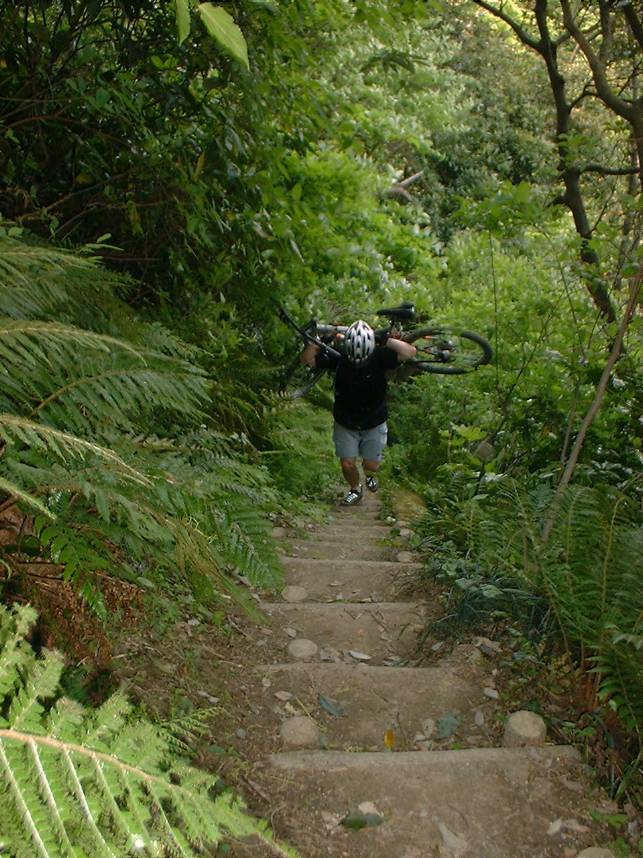
Once onto the dirt I made my way over to the summit that included some hike-a-bike up some stairs. Once on top I was surprised to be treated to some signs of spring. This was quite a contrast to the beginning of the week where it had snowed.


After getting my fill of the sights on the summit I backtracked a bit and got on what was supposed to be my main trail to shed off some elevation in nice single track fashion.

I was quite bummed to see the trail I was looking to take was well blocked off. None of the other options I knew were appealing as they would put me on the other side of the peninsula, involve hundreds of steep steps carrying a bike or go back the way I came.

There was a map nearby that clearly laid out in Japanese what to do with the situation. It was a real bummer to see how much of the trail was closed. I was hoping that the reroute would not be some hike a bike down BS. Just when I was about to roll out a hiker came up and was looking bewildered into her phone. She clearly asked me for directional help but my Japanese has atrophied down from his highpoint of bad some number of years ago. After a couple of rounds of international charades and collective pointing at her phone I figured out where she wanted to go. The trail down the mountain she needed to take was no shown on her phone. It was not much of a back track for me so I rode back with her following and got her on the right trail. I remembered the trail as it is a calf burning hike-a-bike on the way up that is not easily forgotten.

My good deed for the day done, I started off on my reroute. The trail it took me on started out quite flowing but soon turned quite steep. Luckily it was not also slick so some technical roots and crotch riding the rear wheel took me down to a street. The reroute then took me through what looked like somebody’s backyard farm before I was back on a micro-sized residential street. After a bit on the street I was off onto a single track and then back to gravel road. Shortly thereafter I popped out at the bottom of the closure and familiar ground. While I was bummed about the section of trail I could not ride, the forced route finding and new bits of trail I went on was a nice bit of unplanned adventure.

The next section of trail was just as nice as I remembered it and it popped me out near the entrance to a couple of shrines and temples. Checking these out were not on the agenda today (I have toured them before) so I continued along the remainder of my old lunchtime loop route.
Here is the spot on Google Maps. There are four pins in area for the shrines and temples that include photos as well.
The remainder of the ride was street riding back to my hotel. There were not further navigational misdeeds on my part. It was great day to be wandering around on Nippon dirt!